This article represents a diversion for SublimeSites, away from its usual focus on Turner, Cotman and Ruskin, to an artist who may be less familiar to readers, but is a long-held interest of mine. John Atkinson Grimshaw (1836-1893) was a Leeds- born artist, who practiced most of his career in Leeds and who by any standard ought to be ranked as one of the major artists of the later nineteenth century. It can be claimed that his paintings almost single-handedly define the image of the Victorian city and its suburbs. He certainly defines high Victorian Leeds and its leafy-stone-walled suburbs and parks. This may be the beginning of a series of explorations of Grimshaw’s Leeds, but for the present I want to concentrate on one picture in particular, a watercolour called ‘Leeds from Woodhouse Ridge’, painted in 1868 and bought by Leeds City Art Gallery in 2013 with the assistance of the Leeds Art Fund. This was the pretext for several excursions along Woodhouse Ridge, Meanwood Valley and around the Victorian streets of Headingley as spring began to suggest itself in January and February 2015.

Leeds from Woodhouse Ridge, 1868
Pencil and watercolour, 10 ½ x 17 ½ ins, 273 x 445 mm
Leeds City Art Gallery, bought with the assistance of the Leeds Art Fund, 2013.
Photo courtesy of Leeds Museums and Art Galleries
Click on image to view at full size.
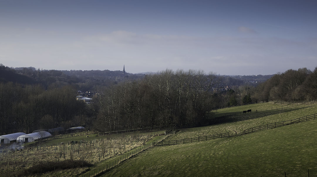
Photograph by David Hill, taken 10 February 2015, 15.36
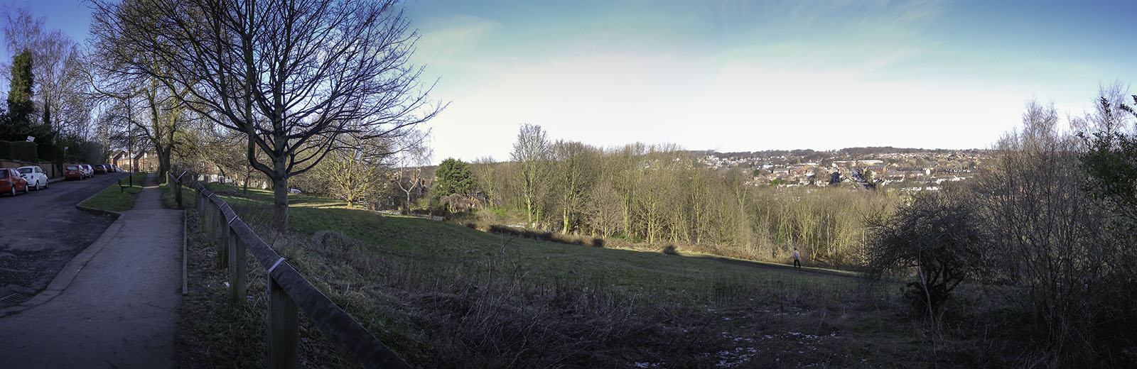
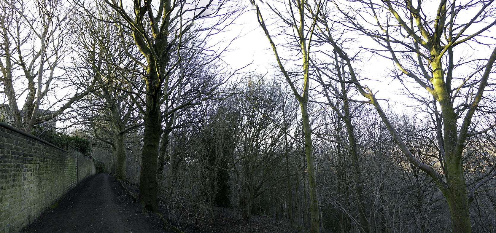
Taken on the same line of sight as Grimshaw’s watercolour, but from further back. Grimshaw’s exact viewpoint can be made out to the left, where Woodhouse Ridge turns away towards Headingley.
Click on image to view at full size.
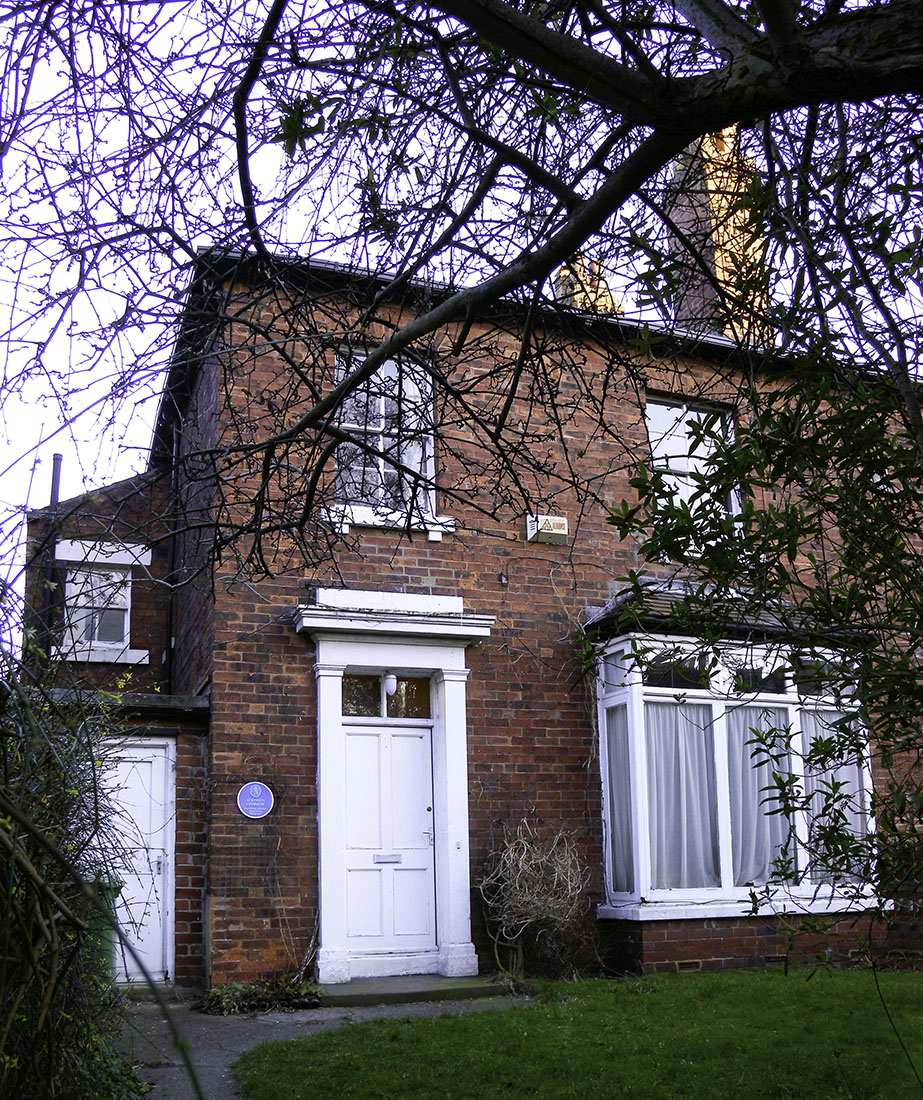
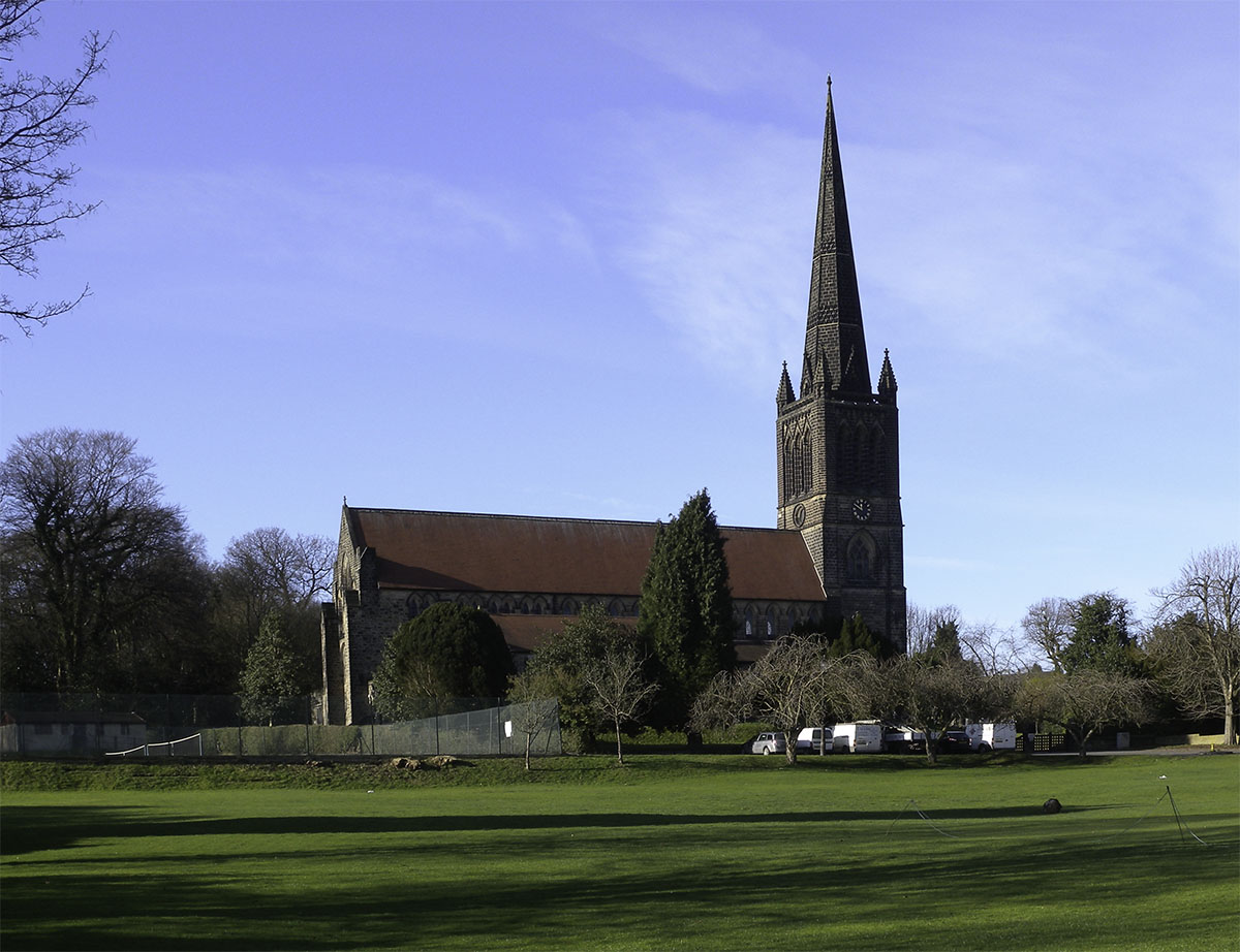
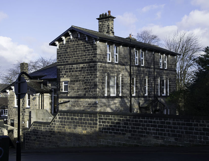
It took a little while to establish Grimshaw’s exact viewpoint. When the watercolour was shown (as no.20) in the Atkinson Grimshaw exhibition at Leeds City Art Gallery in 1980, Alex Robertson wrote ‘The view is painted from Batty’s Wood, Woodhouse Ridge, Leeds, looking towards St Chad’s Church, Far Headingley. This spot is a few minutes’ walk from the Grimshaw house, The Villas in Cliff Road.’ Woodhouse Ridge is the north-facing slope of Meanwood Valley rising gradually from Sheepscar to the east towards Headingley in the west. The summit of the ridge falls away southwards towards the Otley Road. The area was still relatively open when the 1851 Ordnance survey was published, but became a major building site soon after then. It was developed first with genteel, and sometimes grand houses, and afterwards filled in with much more dense terraces. It survives full of University residences, Professorial dwellings and student lets, a typical leafy high Victorian Leeds residential area. In 1866 Atkinson Grimshaw himself occupied a recently built semi-detached house in Cliff Road, which runs up from Otley Road to Woodhouse Ridge, not far beyond the Hyde Park pub. It was a step-up to suburban living for him. He was beginning to establish himself as a painter, and could afford to move to a leafy neighbourhood.
Photograph by David Hill, taken 3 February 2015, 16.01.
Grimshaw moved to this recently built semi-detached house in 1866 and lived there with his family until 1870. During this time he developed his career as a painter, and could afford to live in the leafy suburbs. He painted the watercolour of Leeds from Woodhouse Ridge in 1868 while he was living there. He could walk onto the ridge at the top of his street, and the viewpoint was a few minutes’ walk away through the woods.
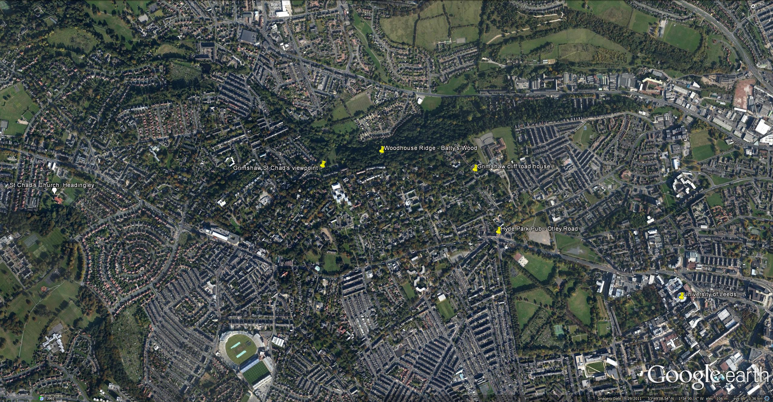
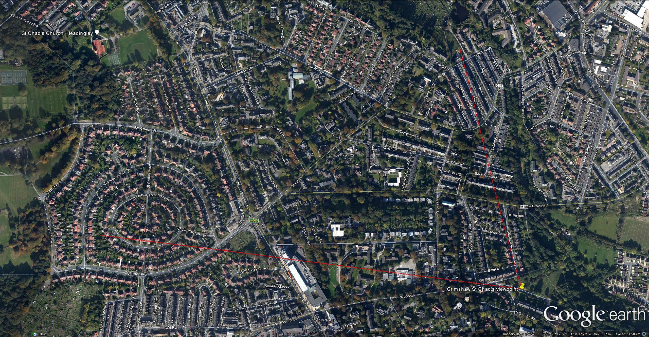
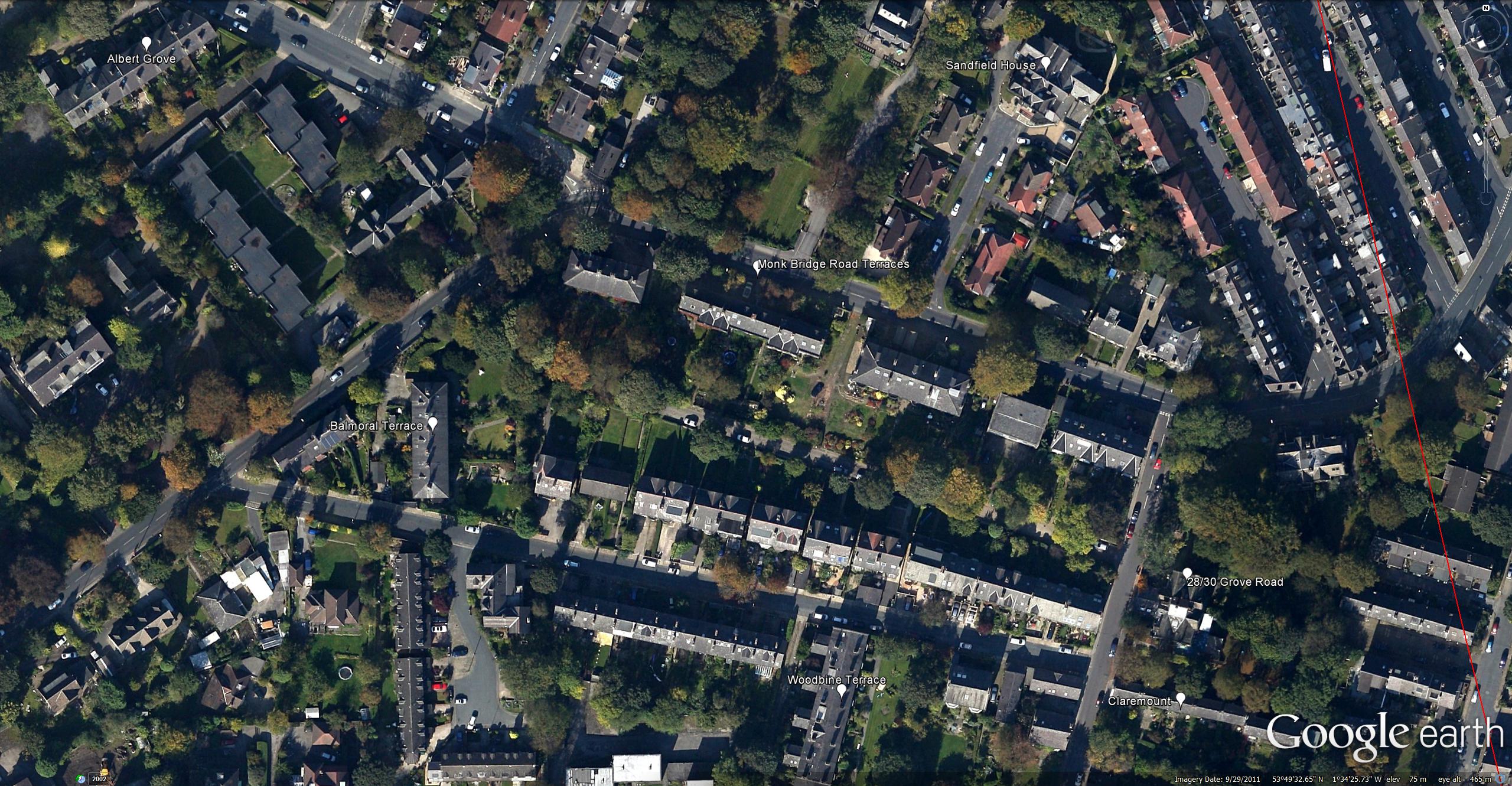
Google Earth Satellite View, marking St Chad’s, Woodhouse Ridge, Grimshaw’s Cliff Road House and the University of Leeds
Click on image to at view full size.
Neither Cliff Road nor Grimshaw’s House had yet been built. The site is the second field to the right of Grosvenor Terrace. Grimshaw’s viewpoint is at the top left of the map.
Click on image to at view full size.
Batty’s Wood is the westernmost stretch of Woodhouse Ridge, and is as Alex Robertson said, only a few minutes’ walk from Grimshaw’s house in Cliff Road. Just beyond Batty’s Wood the trees give way to a stretch of open meadow. Today this is colloquially known as ‘Cardboard Hill’ on the grounds that successive generations of children (and students) have thrown themselves down it on cardboard sledges. It is here, rather than in Batty’s Wood that Grimshaw’s view to St Chad’s opens up, or, rather would open up if the terraces at the end of Wood Lane and of Woodland Park Road did not now impede the view. Despite that we can work from the angles of view St Chad’s and the various buildings in view in the watercolour to be sure that the exact viewpoint is on Ridge Terrace above Cardboard Hill, just at the point where it curves round into Wood Lane. Despite the occlusion of St Chad’s the site is still recognisable; the open flower-filled meadow still has the character that Grimshaw records of it in his watercolour.
Photograph by David Hill, taken 3 February 2015, 11.27
Looking along Ridge Terrace towards Wood Lane, at the north-western end of Woodhouse Ridge. The grassy slopes are called ‘Cardboard Hill’ recalling their use for cardboard sledging. Grimshaw’s view is obscured by the houses at the end of Wood Lane, but the flower meadows remember the character that Grimshaw records in his watercolour.
Click on image to view at full size.
Photograph by David Hill taken 3 February 2015, 11.20
Click on image to view at full size.
In order to give the sense of the location and the view to St Chad’s, I photographed the site from further back on the same line of sight, on the opposite side of Meanwood valley. In my photograph Grimshaw’s exact viewpoint can be seen to the left, where the wooded slopes of Woodhouse Ridge turn away from us towards Headingley.
Leeds from Woodhouse Ridge, 1868
Pencil and watercolour, 10 ½ x 17 ½ ins, 273 x 445 mm
Leeds City Art Gallery, bought with the assistance of the Leeds Art Fund, 2013.
Photo courtesy of Leeds Museums and Art Galleries
Click on image to view at full size.
Showing the field of view of Grimshaw’s watercolour.
Click on image to view at full size.
Grimshaw’s viewpoint is a little further round towards Headingley than I had originally thought. My first surmise was that the valley before us must be Meanwood valley, with various old mills and cottages dotted around on its flanks. In fact Meanwood valley is out of the frame to the right and we are looking across the line of Grove Lane. For anyone interested in following this up on a map or Google Earth, or (even better) on the ground, the left hand edge of the composition more-or-less looks down the line of Wood Lane. Having finally established my bearings, it became possible to start thinking about what might be discovered about the buildings that Grimshaw records. This turned out to be more productive than I could have predicted, and might furnish the interested researcher numerous aspects for further enquiry.
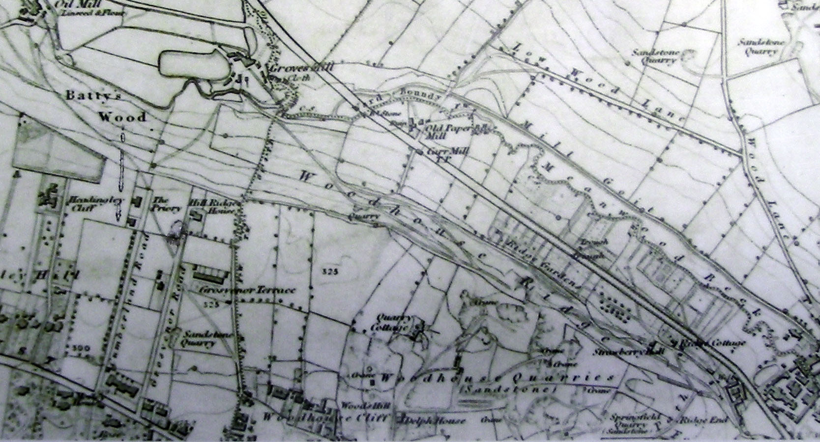
Almost every building in the field of view appears to survives to this day and may be identified. Furthermore, every single one was almost brand new when Grimshaw painted this in 1868. If he had sat here twenty years earlier when it was mapped by the Ordnance Survey, he would have seen nothing but fields.
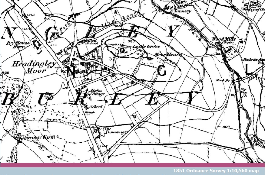
These commons were subject to enclosure 1829-34. At the time of the survey none of the buildings shown by Grimshaw were present. Following a series of land auctions in 1851 and 1852, the area became dotted with bourgeois residences and good stone terraces to rent.
Click on image to view at full size.
The far side of Grove Lane was common land known as Headingley Moor, and almost completely undeveloped before the early 1830s. At that point the absentee landlord the Earl of Cardigan got into cahoots with the other smaller freeholders to deprive the residents of Headingley of their commons. Enclosure was a process that had gathered momentum throughout the eighteenth century. In the name of ‘progress’ and ‘improvement’, Parliament allowed the freeholders of a parish to take ownership of the commons and divide them up amongst themselves. Thus cottagers were deprived of independent sustenance (an allotment, a little grazing, foraging for fuel, hunting for rabbits etc) and became entirely dependent on wage labour. It’s a long and terrible story, and a through indictment of Parliament’s siding with the interests of Capital. If you have never thought about this, you should read J L Hammond and Barbara Hammond, The Village Labourer. This was first published in 1911, but there is a more recent (1978) edition. If everyone were to read this between now and May, the result of the General Election might be dramatically skewed.
The story of the enclosure of Headingly Commons is told by Eveleigh Bradford in her book Headingley: ‘This Pleasant Rural Village’, published in 2008. Briefly, Cardigan petitioned Parliament for an act in 1829, and the final award of the commons to the landowners was made in 1834. The land was divided up and fenced off, and a few plots at Far Headingley – mostly on the Otley Road around the junction with Weetwood Lane – were built upon with a new village of artisanal houses and services. The 1851 Ordnance Survey map shows no new building on the moor except around Far Headingley village but in the year of its publication there was a series of sales of plots for building development and by the time of Grimshaw’s watercolour of 1868 the commons were dotted over with stone-built bourgeois houses with large gardens and several terraces of good solid houses for rent. All of them can be visited in a single perambulation.
Photograph by David Hill, taken 3 February 2015, 11.53
St Chad’s was concecrated in January 1868, so was brand new when Grimshaw painted his watercolour.
Click on image to view at full size.

Photograph by David Hill, taken 3 February 2015, 12.12.
Click on image to view at full size.
The most conspicuous object in the picture, the spire of St Chad’s Church is also one of the newest. It rather surprised me to discover that the church was only consecrated in January 1868. So when Grimshaw painted the watercolour, it must have been in the certain consciousness that the landscape had been impressed with a millennial mark of occupation, community and optimism. St Chad’s is a large church. It could easily accommodate a congregation of several hundred. At the time this must have been rather more than could be mustered. It was intended to cater for, even provoke, a significant migration into its parish. My first thought on seeing the watercolour was that it was another picture of settled harmonious establishment; the kind of Arcadian idyll that was the stock-in-trade of the ordinary eighteenth and early nineteenth century landscape artist. It is quite the reverse as it turned out; Grimshaw was taking the appearance of traditional landscape but using it to reveal instead a dynamically evolving modernity.
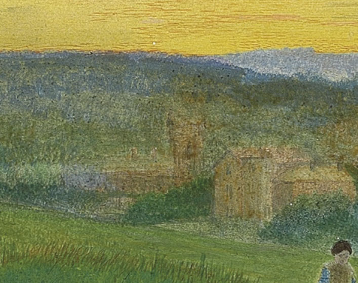
The near side of Grove Lane, in the area of Wood Lane and Alma Road was developed with large architect-designed houses for wealthy families moving out of central Leeds to the more salubrious air of Headingley. The most prominent in Grimshaw’s view can be identified as Ashfield House, built about 1860 and attributed to the architect of Leeds Town Hall, Cuthbert Brodick. Moving left, we can see Wheatfield Lodge built about 1855 and possibly also by Brodick, and finally furthest right, Moorfield House built 1855-6 for William Glover Joy, a manufacturer of seed oil, who became Lord Mayor of Leeds the year after the watercolour was painted. The house names seem to be derived from the original field names on which they were built – at least ‘Wheat Field’ appears on the 1711 survey of Cardigan Lands reproduced in Bradford 2008.
Leeds from Woodhouse Ridge, 1868 (detail of Ashfield House, centre)
Leeds City Art Gallery
Photograph courtesy of Leeds City Art Gallery.
Click on image to enlarge.
Photograph by David Hill, taken 6 February 2015, 14.56
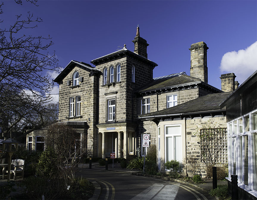
Ashfield stands at the junction of Alma Road and Grove Road. It was built as a private house about 1860 and was possibly designed by Cuthbert Brodrick, the architect of Leeds Town Hall. It is now divided into flats.
English Heritage listing: http://list.english-heritage.org.uk/resultsingle.aspx?uid=1256100
Click on image to enlarge.
Leeds from Woodhouse Ridge, 1868 (detail of Wheatfield Lodge, centre)
Leeds City Art Gallery
Photograph courtesy of Leeds City Art Gallery.
Click on image to enlarge.
Photograph by David Hill taken 6 February 2015 14.59
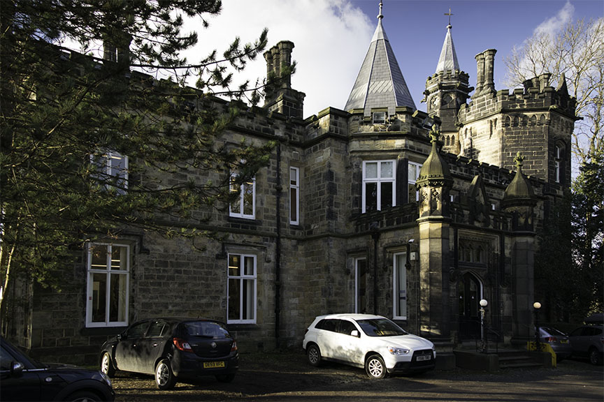
Wheatfield Lodge was built about 1855, on the plot on the west side of Grove Road between Wood Lane and Alma Road. It is diagonally opposite Ashfield, across Grove Road. It was greatly extended about 1900, but the south front of the original house, consisting of the gable and square tower seen in this photograph, and in the Grimshaw watercolour, bears some resemblance in detail to Ashfield, and may be by the same architect. Wheatfields today serves as a very well-known hospice.
English Heritage listing: http://list.english-heritage.org.uk/resultsingle.aspx?uid=1255681
Click on image to enlarge.
Leeds from Woodhouse Ridge, 1868 (detail of Moorfield House, centre – with Wheatfield Lodge to the right)
Leeds City Art Gallery
Photograph courtesy of Leeds City Art Gallery.
Click on image to enlarge.
Photograph by David Hill taken 6 February 2015, 15.12.
Moorfield House was built 1855-6 for William Glover Joy, who became Lord Mayor of Leeds in 1869. Its principal feature is the large octagonal tower at the right, which can be made out in Grimshaw’s watercolour. The house is now offices.
English Heritage listing: http://www.imagesofengland.org.uk/Details/Default.aspx?id=464803
Click on image to enlarge.
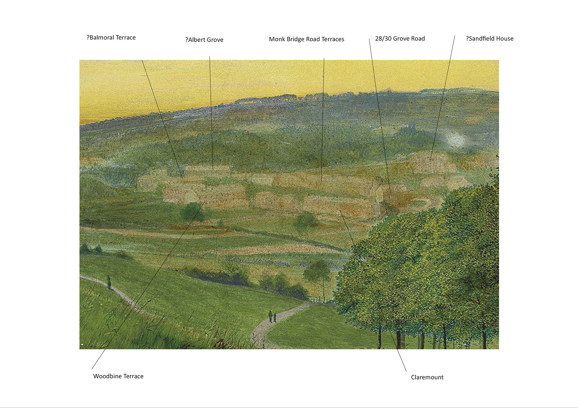
On the Far Headingley side of Grove Lane developers focused on more middle-class housing. The overall history of suburban development in north Leeds is explored in detail in a 1977 University of Leeds Ph.D thesis by Colin Treen, ‘Building and Estate Development in the Northern Out-Townships of Leeds, 1781-1914’, which is available online at http://etheses.whiterose.ac.uk/1399/1/uk_bl_ethos_528443.pdf. His chapter 5 ‘Building and Estate Development, 1847-1870’, particularly 5.4 ‘New Building Estates of the 1860s’, gives specific information and sources for the development of Headingley Commons. The broad picture is that developers in the area concentrated mainly on building for rental. There were local quarries and established masons took on a variety of different projects, but the majority were terraces of decent stone-built houses, varying between double-fronted aspirational properties that rented for about £12 a year and more modest, but still solidly stone-built, properties renting for about £8 a year. It is remarkable that the larger houses would fetch well over half a million in today’s market, and rent for up to £15,000 a year. Most of the houses shown by Grimshaw are identifiable today: The nearest to the right is Claremount, with a substantial pair of gabled semi-detatched houses – 30/28 Grove Road immediately behind on the upslope. Behind Claremount is a line of terraces on Monk Bridge Road. There are in fact three separate terraces, but Grimshaw’s drawing does not clearly distinguish between them. Below that to the left, and at right angles to Claremount, running down the slope towards Grove Lane, is Woodbine Terrace. This was built in three phases, and considerably extended, but only the first phase is shown here. Thereafter to the left Grimshaw’s drawing is a little hard to read. Beyond Woodbine Terrace is Balmoral Terrace, and beyond this group is Albert Grove, just off Moor Road, but there remains some uncertainty about their identification with the buildings shown in the watercolour. Finally, at the right, above 30-28 Grove Road on this line of sight is what appears to be a significant detached villa. This might be identifiable as Sandfield House, recently converted into apartments, but whose history remains to be established. There is the potential for a much more detailed chronology of the construction sequence – and the naming of the terraces, than I have been able to accomplish here. Treen 1977 has some specific detail (especially see page 211 ff.) and Eveleigh Bradford has written in detail on Woodbine Terrace in her ‘A Respectable Terrace – The Story of Woodbine Terrace’, (2000), but much more might be discoverable. Suffice it to say that the early development is easy to distinguish, for it is all of stone. The later developments, with the exception of Oakfield Terrace (started 1871) favour brick. As development progresses towards the end of the nineteenth century, and the first Leeds tram line was brought to Headingley the market was for more affordable properties, and the building economy was geared up almost exclusively for brick. Grimshaw records the area just as the initial phase of stone building came to its climax, and just before the infilling with brick began.
Leeds from Woodhouse Ridge, 1868 (detail of Terraces beyond Grove Lane)
Leeds City Art Gallery
Photograph courtesy of Leeds City Art Gallery.
Marked with identifiable developments. There is considerable room for further research here; especially to establish a detailed chronology of development in this area, and the original names of properties, occupiers, builders etc.
Click on image to enlarge
The right edge of Grimshaw’s field of View is given in red at the right
Click on image to enlarge.
Photograph by David Hill taken 10 February 2015, 16.05.
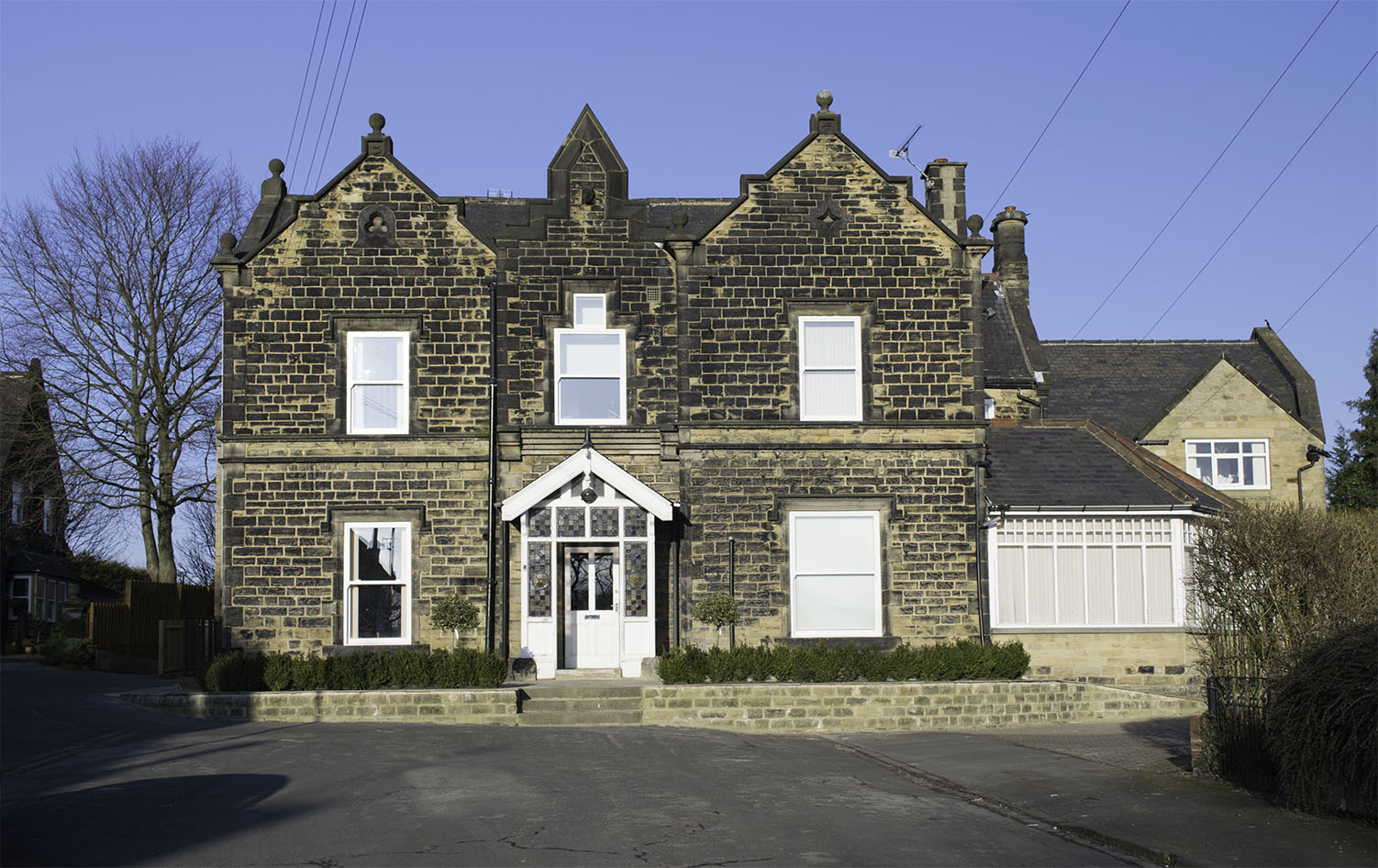
I have managed to establish very little about this splendidly gabled pair of semi-detached houses. No.28 named ‘Rupert Lodge’ on its gatepost is now Treetops Nursery, no.30 named ‘Milton Lodge’ is a private house. The building is clearly identifiable in Grimshaw’s watercolour, with its paired gables facing north, south east and west. Grimshaw’s angle of view is from the south east, with no.28 in front. This photograph is taken from the opposite angle with no.30 in front, to give the corresponding aspect of a symmetrical building. There is an almost identical pair of houses immediately to the north-east, with its gateways around the corner in Monk Bridge Road.
Click on image to enlarge.
Photograph by David Hill, taken 10 February 2015, 16.27
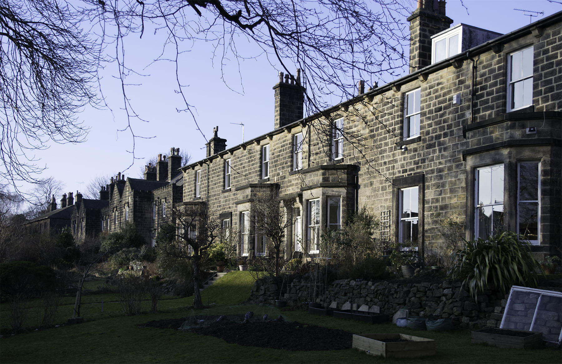
Grimshaw seems to show this as one continuous development, but there are in fact three separate terraces. That to the east is of three houses; the central block is of four, and the westernmost of two. The centre block appears to have been called ‘Marlborough Terrace’ from the now weathered name on one gatepost. Another was called ‘St George’s Terrace’. These are some of the most aspirational of the terraces in this area and were built by George Vevers in the later 1850s. The central block is listed, cf
http://www.britishlistedbuildings.co.uk/en-466076-6-12-monk-bridge-road-
Click on image to enlarge.
Photograph by David Hill, taken 10 February 2015, 16.40
Grimshaw shows this clearly running at right angles to most of the other terraces. The first phase was built 1867-70 by John Wood, a local builder, so work must have been continuing at the time Grimshaw made his watercolour in 1868. For English Heritage listing see:
http://www.britishlistedbuildings.co.uk/en-488218-1-14-woodbine-terrace-off-grove-lane-
Rather nicely, and perhaps not altogether co-incidentally Grimshaw’s daughter, Elaine, came to live at 11 Woodbine Terrace. The photographic archive Leodis has images of Elaine and her family in the garden. Cf
http://www.leodis.org/searchResults.aspx?LOCID=9999&DECADE=0&YEAR=&KEYWORDS=John%20Atkinson%20Grimshaw&KEYWORDS2=&KEYWORDS3=&ANDOR2=&ANDOR3=&RECSPAGE=5&VIEW=1&CURRPAGE=1
Click on image to enlarge.

Photograph by David Hill taken 10 February 2015, 16.23.
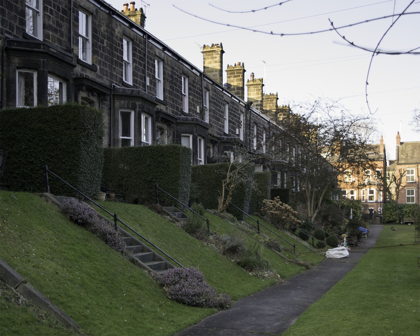
A terrace of three substantial double-fronted houses built by George Vevers c.1857, in suite with his adjacent terraces in Monk Bridge Road. For English Heritage listing see:
http://www.britishlistedbuildings.co.uk/en-489770-balmoral-terrace-
No.1 was the family home of the Phillips family. Grimwshaw’s daughter Elaine married Edmund Ragland Phillips, who was councillor for Headingley ward 1907-1911. The photographic archive Leodis has photographs of the family and their children at Balmoral Terrace and at their own home at 11 Woodbine Terrace, nearby.
http://www.leodis.org/searchResults.aspx?LOCID=9999&DECADE=0&YEAR=&KEYWORDS=John%20Atkinson%20Grimshaw&KEYWORDS2=&KEYWORDS3=&ANDOR2=&ANDOR3=&RECSPAGE=5&VIEW=1&CURRPAGE=1
Click on image to enlarge.
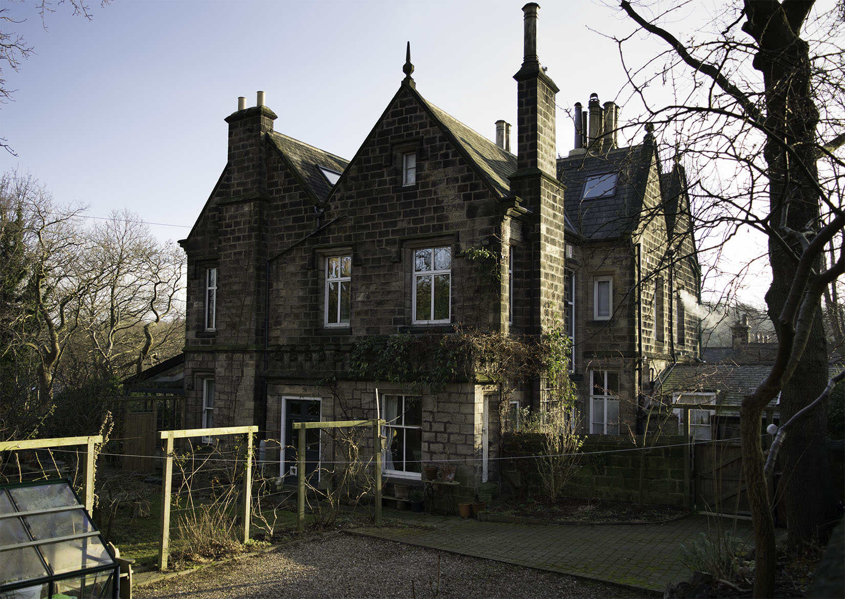
Photograph by David Hill taken 10 February 2015, 16.15.
Possibly the house indicated in Grimshaw’s watercolour furthest back at the right. Sandfield House, recently converted to apartments, stands on this exact line of sight, but I have not been able to establish the date of the building and Grimshaw’s detail is too faint to be certain of the identification.
Click on image to enlarge.
Leeds from Woodhouse Ridge, 1868 (detail of paths to the right)
Leeds City Art Gallery
Photograph courtesy of Leeds City Art Gallery.
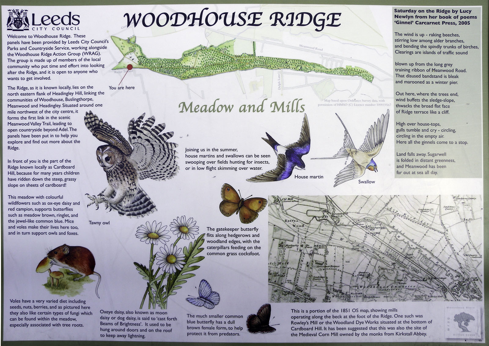
Finally it might be worth returning to Grimshaw’s viewpoint to think a little more about Batty’s Wood and Woodhouse Ridge. One feature recorded by the watercolour but not yet discussed is the paths coming together at Batty’s Wood at the right. It is worth remarking that they are a slightly odd lilac colour. The rough paths in this area now are the brown of leaf mould and bare earth. Their colour in Grimshaw suggests that they have been surfaced with stone chippings.
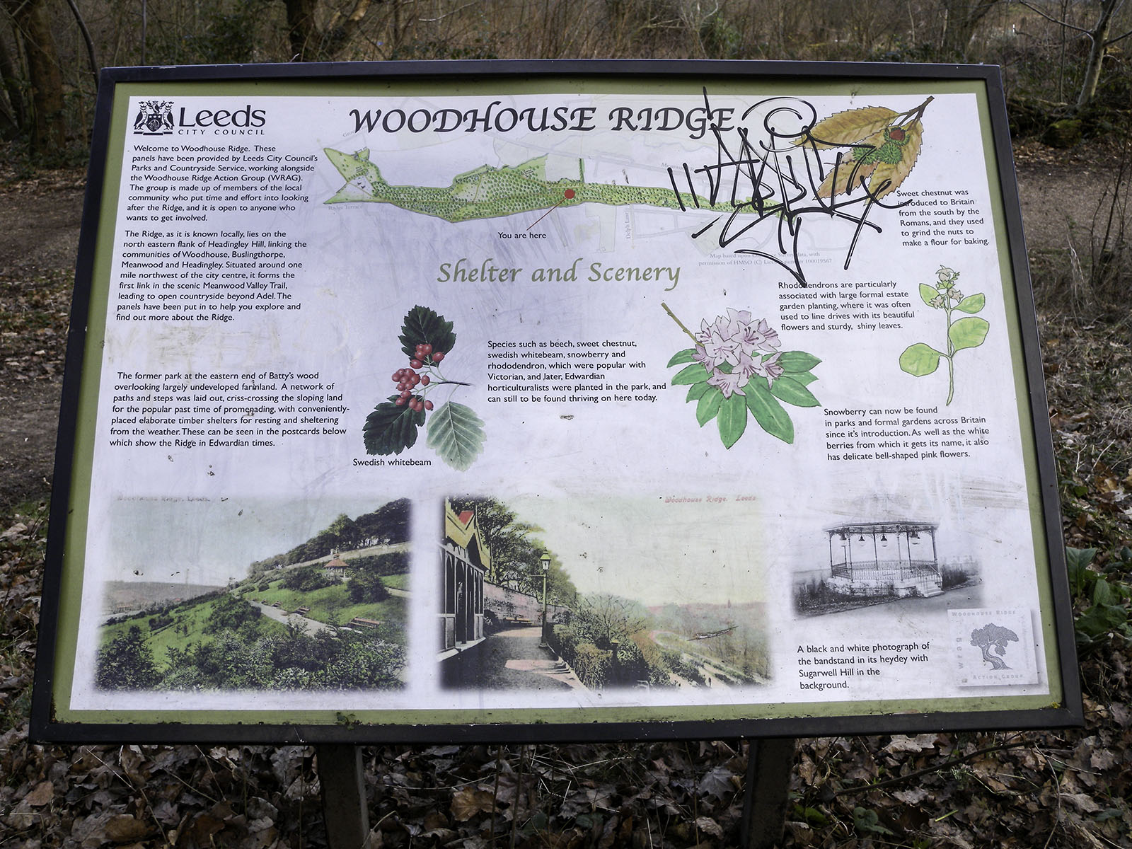
Photograph by David Hill taken 3 February 2015, 11.01
Click on image to enlarge
This would be in keeping with the maintenance of this area as a public park. In 1876 Woodhouse Ridge was given to the people of Leeds as a recreational space, and Batty’s Wood followed in 1901. This formalised the established recreational use that Grimshaw depicts in his watercolour, and the Ridge acquired a bandstand and terraced pathways on which considerable numbers gathered in pleasant weather. The more generally wooded character of the Ridge today is, ironically, more a symptom of less intensive use rather than more. The might well be a case for clearing and maintaining a few areas, although it is hard to see the Council spending anything on such things while the public continue to pay off the cost of bailing out the bankers in 2008.
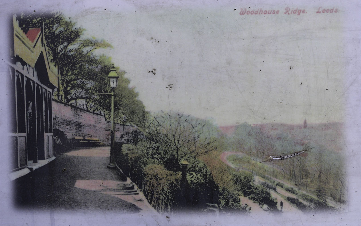
(From Woodhouse Ridge History Board)
Click on image to enlarge
Photograph by David Hill, taken 3 February 2015, 15.44
Click on image to enlarge.
Grimshaw’s theme is entirely of the new, and of the suburban utopia that was being realised in this area. We are used to thinking of Paris or Chicago as the new centres of modern consciousness, but in truth Leeds was as much in the vanguard of social change as anywhere on earth. It has a claim to be the occasion of the world’s first industrial cityscape in Turner’s watercolour of Leeds in 1816 (see David Hill, Turner and Leeds: Image of Industry, 2008). It was the prototype of urban and suburban development, turning itself into a choking, filthy sump, and a crucible for every social issue and opportunity that a modern industrial conurbation could afford. When Grimshaw set up his easel at the north end of Woodhouse Ridge in 1868, he was engaged in social observation through a process mediated by naturalism and photography. The ladies enjoying their leisure amongst the long grass on this summer’s evening, were asserting a right to chose a modern middle glass indulgence, that of leisure. Grimshaw’s picture is about the pleasure of viewing, and of leisure being the subject of the view. It might be remarked apropos of Leeds as a crucible of modernism, that Grimshaw’s picture is five years earlier than Monet’s Wild Poppies of 1873.


So we might be surprised that Grimshaw’s picture turns out to be rather cutting-edge. Certainly we can say that the high Victorian suburban environments created in Leeds were in quality second to none. Grimshaw’s Leeds is a rather special legacy. Walking through this area this Spring, looking past its temporal passages of untidiness, litter and unkemptness, I could not help but wonder whether the current inhabitants quite sufficiently appreciate what an exceptional place to live this is. Grimshaw’s watercolour records the point at which the fields of Headingley were being first built upon, but with the intention of creating what Grimshaw clearly felt could be the model of new living; the leafy, mossy-walled aspiration of suburban Modernity.
POSTSCRIPT
Photograph by David Hill taken 6 February 2015, 14.51.
Click on image to enlarge

A fascinating history of the area! Thank you. My husband lived at Rupert Lodge, 28 Grove Road with his ten siblings, parents and a nanny from 1955 until about 1970.
Thank you for responding.
It’s always good to hear when this material finds a reader, even better when one hears from someone with a personal connection to the sites discussed. Rupert Lodge must have been a splendidly lively household. The nanny must have been a remarkable soul.
DH
Indeed she was! Thank you for getting back to me Professor Hill – I have passed your article on to other members of the family and they have said how it has brought back lovely memories of their childhood, including the sledging on the Ridge!
This is a great history of the area. I used to wake up to the view of Woodhouse ridge every day, and since moving away, greatly miss it. I stumbled across your article whilst looking for paintings depicting headingley and so glad I got to read this. Thank you.
Thank you for taking the trouble to respond.. It’s always encouraging to hear when this material is read and enjoyed!
Just to mention, his student Walter Linsley Meegan handled the night quite well. He passed it on.