This article is prompted by a watercolour that Turner made on his tour to the Alps in 1836. That tour was the subject of the exhibition Turner, Mont Blanc and the Val d’Aosta held at the Archaeological Museum in Aosta in 2000. At that time I identified its subject as the French town of Sallanches, in the Savoy Alps. The watercolour was exhibited by Lowell Libson in New York in January 2015, re-identified as Chambery, which was one of the last sites that Turner visited in 1836. The re-identification was made by Ian Warrell in an essay published in Lowell Libson’s 2015 catalogue.* My purpose here is to stand by my original identification: The subject remains Sallanches.

Sallanches, Savoy, 1836
Watercolour, 9 3/4 x 10 3/4 ins, 249 x 273 mm
Exhibited by Lowell Libson Ltd in New York, January, 2015 as ‘’A distant view over Chambéry, from the North, with storm clouds’
This article stands by my 2000 identification of the subject as the view of Sallanches from the northern lip of the Gorges de Levaud, looking down to the Eglise St Jacques, with the Aiguille de Varan in the distance.
Photograph courtesy of Lowell Libson Ltd.
To view this watercolour on the Lowell Libson website click on the following link, then use your browser’s ‘back’ button to return to this page:
http://www.lowell-libson.com/pictures/a-distant-view-over-chambery-from-the-north-with-storm-clouds
Click on image to enlarge
*Lowell Libson’s 2015 catalogue can be downloaded as a pdf by clicking on the link below. Use your browser’s ‘back’ button to return to this page:
Click to access Lowell_Libson_2015.pdf
The watercolour, and Ian Warrell’s article, is at page 120.
Click on image to enlarge
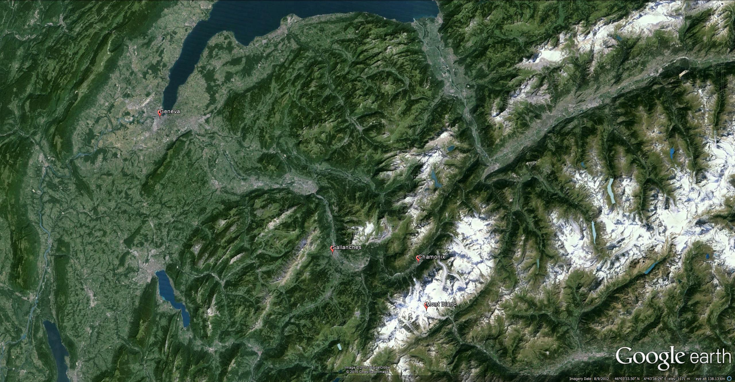
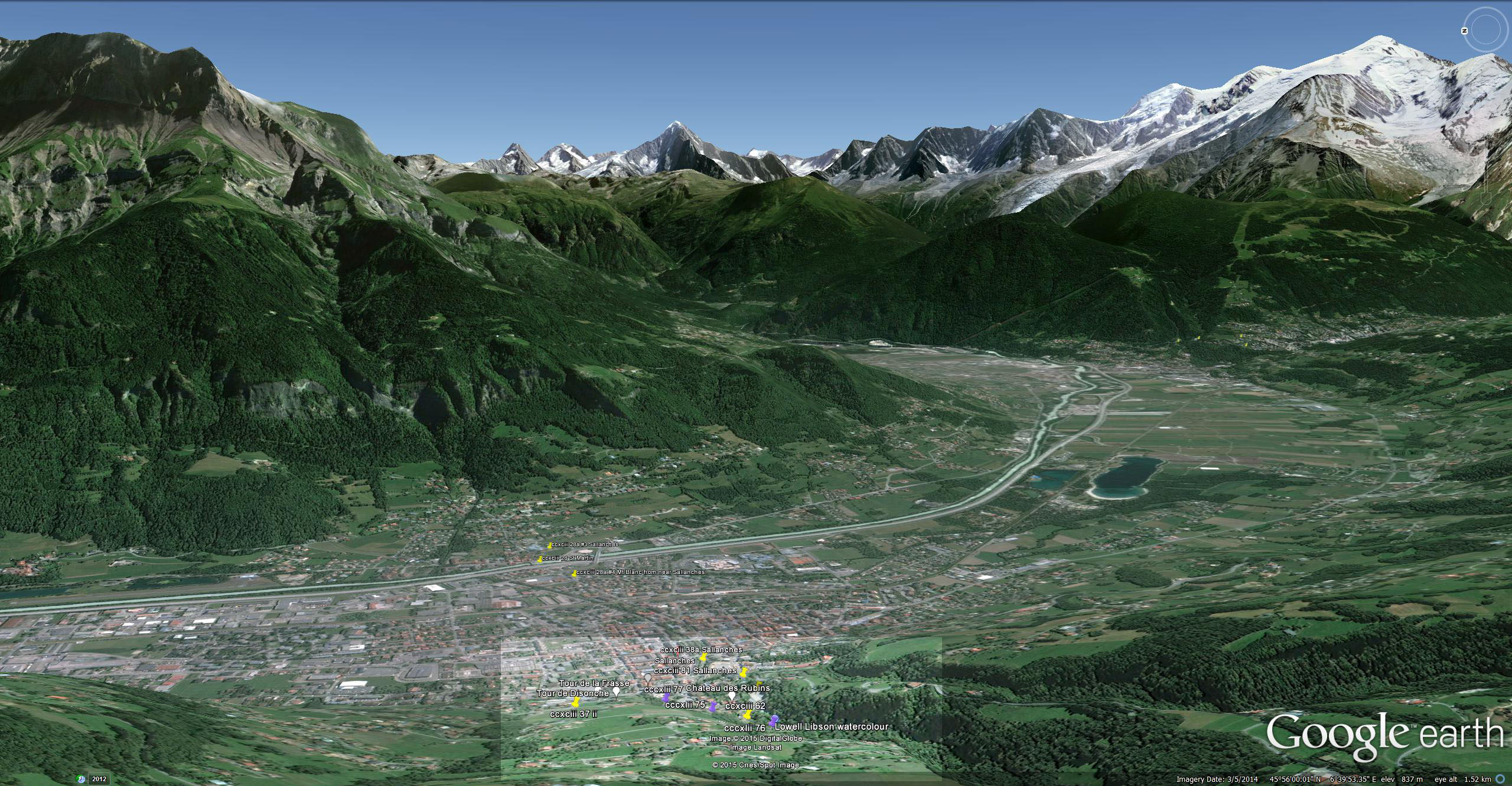
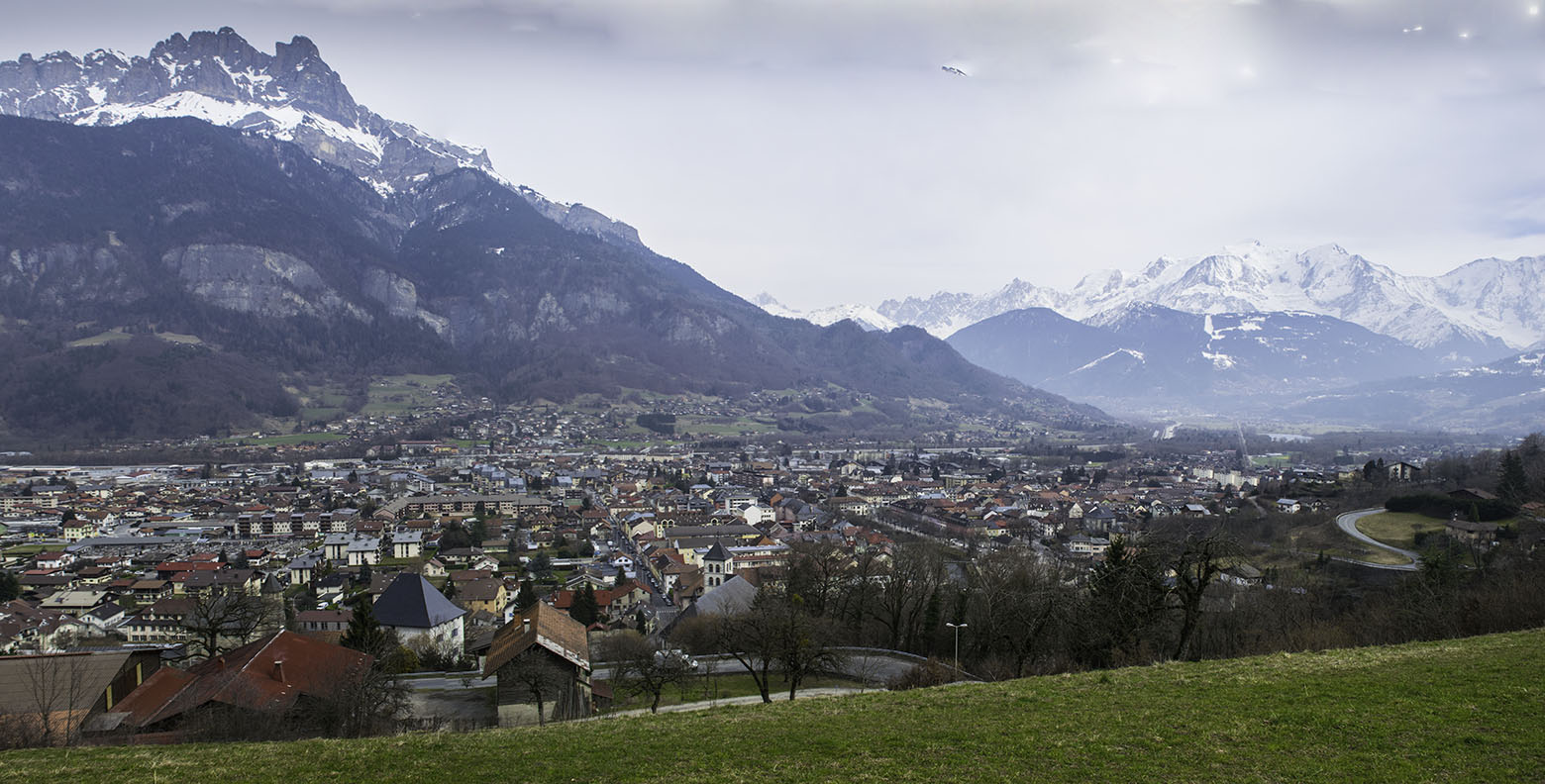
In Turner’s day Sallanches provided a halfway halt on the journey from Geneva to Chamonix. Most modern tourists rush by intent on snowy peaks but for Turner’s generation it was a very special place. As one heads south from Geneva the Arve valley contracts to a gorge at Cluses. Beyond that the valley opens out again, and at Sallanches provides the first sight of Mont Blanc. In my 1992 book Turner in the Alps, in which I traced the footsteps of his first visit to the Alps in 1802, I described this part of the valley as ‘the courtyard of Mont Blanc’, and most travellers took the time to take in the situation, and look forward to getting amongst the peaks. Turner particularly so, and he made several watercolours in the area. In 1836 he was retracing his own footsteps of thirty- four years earlier, and once again took the time to ground himself in the place properly.
He revisited his sites of 1802, and also found new ground to explore on the slopes above Sallanches, finding viewpoints around the valley of the Torrent de Sallanches. My contention is that the Lowell Libson watercolour is the culmination of these explorations.
I have visited Sallanches several times over the past twenty-five years, and taken a number of photographs, but various factors including trees in the gorge, chalet development in the pastures along the lip and various companions intent on hurrying up to the high peaks, prevented my photographing all of Turner’s subjects in the area. I recently revised my material on these sketches for the new catalogue of the Turner Bequest. This may be accessed online at:
http://www.tate.org.uk/art/research-publications/jmw-turner/sketchbooks-used-on-tour-to-the-alps-r1144578#synopsis [Search for ‘Sallanches’]
The exhibition of the watercolour this January, however, prompted a revisit over four Spring days this March, and a systematic review of every subject. Tree growth remains a problem in some cases, but I did manage to find angles on every subject sufficient to confirm his exact vantage points. It became manifest that he frequently worked synthetically with his material. The Tate catalogue material can now be significantly augmented, and a close look at each sketch provides an object lesson in the creativity in his approach to topography in 1836. It contrasts markedly, for example, with his 1828 sketch of Rome from the Aventine (see SublimeSites.co article of 22 January 2015). That is a tour de force of naturalistic placement. His approach in 1836 is to take his topography on a roller-coaster of energised resynthesis, imaginative assimilation and recalibration.
Click on image to enlarge

Click on image to enlarge
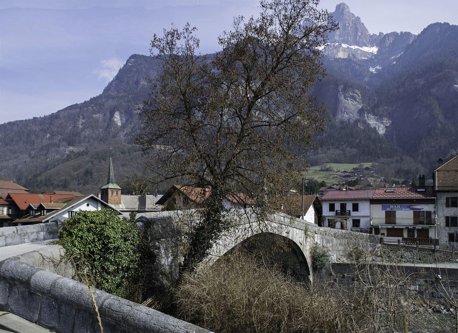
In 1836 Turner visited Sallanches on his way to the Val d’Aosta on the southern side of Mont Blanc. He probably put up at the Hotel du Mont Blanc at the little village of St Martin. At that time the main road to Chamonix ran on the right bank of the Arve, and travellers had to cross the old bridge at St Martin to visit Sallanches.
By the 1830s it was possible to go from Geneva to Chamonix in a single day, and the Hotel du Mont Blanc gradually lost its trade. It became a particular favourite of John Ruskin, who saw it as a symbol of a time when travellers had a proper engagement with the world through which they moved. He titled a chapter of his autobiography Praeterita, after it. This article has a postscript in which I consider one of Ruskin’s studies at Sallanches.
Turner’s previous visit was in 1802, when he was twenty-seven, during his first trip abroad. He remembered his earlier subjects – and must have been reminded how much his practice had progressed and deepened. Working in a sketchbook that he had served him for the entire journey thus far [Val d’Aosta sketchbook, Tate TB CCXCIII] he revisited some of the subjects that he had found in 1802.

Sketches in the Arve Valley (detail), 1836
Pencil on paper, page width 113 mm
From the Val d’Aosta sketchbook, Tate Britain, London, TB CCXCIII 28a (detail of lower part of page)
Turner’s first thought at Sallanches was to reconsider subjects from his previous visit of 1802. Here he takes a two-part panorama of the view of Sallanches from St Martin, swinging round to the left to take in the view of Mont Blanc.
Image courtesy of Tate; to see the original image in the online catalogue of the Turner Bequest click on the following link, then press your browser’s ‘back’ button to return to this page:
http://www.tate.org.uk/art/research-publications/jmw-turner/joseph-mallord-william-turner-five-sketches-in-the-arve-valley-at-cluses-and-sallanches-r1167978

Photograph by David Hill, taken 11 March 2015, 14.08 GMT
Click on image to view full size

Photograph by David Hill, taken 11 March 2015, 12.47 GMT
Click on image to view full size.
Gallery of Turner’s sketches of 1802 and finished watercolours.
Click on any image to open the gallery


In 1802 his main subjects had been the view of Mont Blanc that was the principal focus for the tourist, and the town of Sallanches backed by its green pastures and limestone crags. In 1802 he had made highly worked drawings of a grand old masterly kind; now his notes were very much more nimble and confident in the way that he assimilated the forms. Mont Blanc and the Arve valley now requires no more than a few quick lines, and he is entirely confident in what he has absorbed of the form, and even if the definition of the peaks from Mont Maudit at the left, through to the Domes de Miage at the right is completely unselfconscious, it is entirely relatable, even down to the placing of summit of Le Prarion below the col between Mont Maudit and the Aiguille du Gouter, as indeed it appears from this angle. The sketch of Sallanches records a wide sweep from Les Quatre Tetes at the right to the slopes of Croisse Baulet towards the left. Once again he compresses a large amount of specific information in what appears to be little more than a few glances, and manages to record the cluster of monumental buildings at the debouchement of the Fours de Sallanches. At the centre is the Chateau des Rubins, and then tracking right, the tower of the Eglise St Jacques, the Tour de Disonche and the Tour de la Frasse, swiftly drawn but sufficiently individuated to be easily recognised. They were to become the principal architectural reference points in his subsequent suite of sketches.
Sketches in the Arve Valley (detail of towers at Sallanches), 1836
Pencil on paper, page width 113 mm
From the Val d’Aosta sketchbook, Tate Britain, London, TB CCXCIII 28a )
Image courtesy of Tate; to see the original image in the online catalogue of the Turner Bequest click on the following link, then press your browser’s ‘back’ button to return to this page:
http://www.tate.org.uk/art/research-publications/jmw-turner/joseph-mallord-william-turner-five-sketches-in-the-arve-valley-at-cluses-and-sallanches-r1167978

Photograph by David Hill taken 11 March 2015, 13.10 GMT
Detail of (left of centre) Chateau des Rubins, (centre) Eglise St Jacques, (right of centre) Tour de Disonche and Tour de la Frasse. The key architectural landmarks of Turner’s 1836 studies of Sallanches.
Photograph by David Hill, taken June 1992
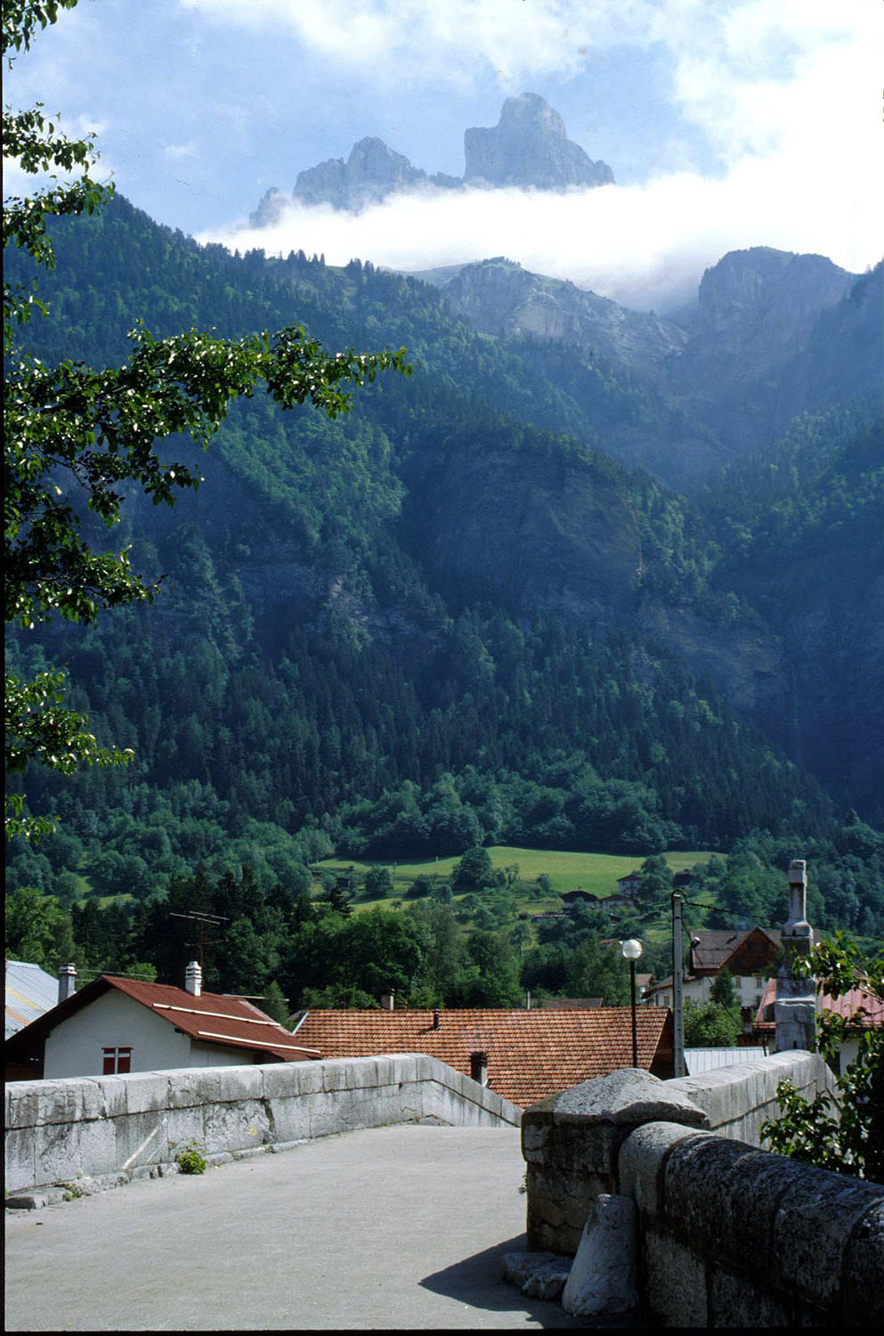
But in 1836 he was also looking for something new. His attention began to gravitate towards the Aiguille de Varan, rising almost two kilometres above the valley floor. He sketched the still-fine view over the bridge, which I first photographed in 1992 when travelling the route for Turner in the Alps. At that time I adopted a portrait format, so as to preserve the sense of verticality. In his 1836 sketch, however, Turner retained the landscape-format of his page in order to include a remarkably wide angle of view. Until my recent visit I had never doubted the straightforwardness of Turner’s treatment of the subject, but on site with a photograph of the sketch in my hand it became obvious that he had treated his observations as entirely malleable. The ‘story’ of the bridge at St Martin is that the Aiguille de Varan towers over it, with the little church of St Martin to the left, and Mont Blanc to the right. The reality is slightly more awkward than Turner’s sketch suggests. If one lines up the Aiguille over the bridge, the church slides out a little to the left. If one lines up the church spire with the Aiguille, as Turner does in the sketch, one has to look over the river from the left, rather than over the bridge. If one is to bring in a sight of the bridge arch, then one has to move to the right, and the Aiguilles slides out to the right. The whole time Mont Blanc is rather too far round to the right to be accommodated. So in the sketch Turner has adopted at least two viewpoints. The first takes the bridge and church spire from slightly upstream. The second takes the whole panorama of the Aiguille de Varan and Mont Blanc, compresses it into the space of the page, and sets the summit of the Aiguille directly over the spire of the church, and brings in Mont Blanc as to be almost over the bridge cross. It was a surprise on site to find Turner so actively manipulating his material in such a straightforward-looking pencil sketch. It was perhaps even more surprising to realise that I had been there several times before and assumed the sketch recorded the site just the way it is. The strange thing is that even having worked through his sleights of hand on site, and even with the photographic evidence before me, my memory insists that the Turner sketch is right, and that the photographs don’t nearly so well record the way that it is. This is all rather different to his practice in the Rome sketches of 1828 discussed in the earlier article. By 1836 Turner was confident enough in his assimilation of a place as to be able to draw its memory directly. It would be an interesting project to try and chart his routine adoption of this process. Presumably it must develop in the interval between 1828 and 1836. As we shall see, it is a practice that that seems well established at Sallanches.
Photograph by David Hill take 11 March 2015, 11.48 GMT
Click on image to open at full size

The Aiguille de Varan from across St Martin’s bridge, near Sallanches, 1836
Pencil on paper, page size 113 x 190 mm
From the Val d’Aosta sketchbook, Tate Britain, London, TB CCXCIII 28
Turner probably stayed in the Hotel du Mont Blanc at the far side of the bridge. The summit of the Aiguille de Varan is nearly two vertical kilometres above the bridge.
Image courtesy of Tate; to see the original image in the online catalogue of the Turner Bequest click on the following link, then press your browser’s ‘back’ button to return to this page:
http://www.tate.org.uk/art/artworks/turner-the-aiguille-de-varan-from-st-martins-bridge-d29086

Photograph by David Hill taken 11 March 2015, 11.55 GMT
Click on image to open at full size
The Aiguille de Varan figured as his constant reference in every one of the sketches he made at Sallanches in 1836. Another subject was a quick note of the view down the Torrent de Sallanches as it runs through the village down towards the Arve. The Aiguille de Varan is in the background:
Two Sketches: Sallanches in the Arve Valley; Avise in the Val d’Aosta (detail), 1836
Pencil on paper, page width 113 mm
From the Val d’Aosta sketchbook, Tate Britain, London, TB CCXCIII 38a detail
From Sallanches, looking down the torrent de Sallanches to the Aiguille de Varan
Image courtesy of Tate; to see the original image in the online catalogue of the Turner Bequest click on the following link, then press your browser’s ‘back’ button to return to this page:
http://www.tate.org.uk/art/research-publications/jmw-turner/joseph-mallord-william-turner-two-sketches-sallanches-in-the-arve-valley-avise-in-the-val-r1167996
Photograph by David Hill, taken September 1999
But his main objective was a view of the Aiguille from above the town, so he set off up the Route de Doran past the Church of St Jacques. At the first bend in the road he paused to take a sketch looking back to the church between the Tour de la Frasse on the left, and the Tour de Disonche on the right, with Mont Blanc over the church tower to the right. Once again, I was surprised by Turner’s syntheticism. The church tower can indeed be framed between the foreground buildings, and the turret made to aspire to Mont Blanc. I photographed this grouping in 1991, but did not realise at that time that Turner had grafted two different views together. He first sketched the buildings and Mont Blanc from a similar angle to the photograph, and then shifted his position higher and further right so that he could compress the wider panorama and slide in the view of the Aiguille de Varan.

Two Sketches: Looking Down the Val d’Aosta to Courmayeur and Dolonne, and The Aiguille de Varan and Mont Blanc from Above Sallanches (detail of the sketch of Sallanches), 1836
Pencil on paper, page width 113 mm
From the Val d’Aosta sketchbook, Tate Britain, London, TB CCXCIII 37 detail
With the Tour de la Frasse and the Tour de Disonche framing the Church of St Jacques. Turner incorporates two different viewpoints in the one sketch, so as to more tellingly integrate the buildings with the mountains.
At this time the church tower had an onion spire on its turret. This was the casualty of a fire in 1840.
Image courtesy of Tate; to see the original image in the online catalogue of the Turner Bequest click on the following link, then press your browser’s ‘back’ button to return to this page:
http://www.tate.org.uk/art/research-publications/jmw-turner/joseph-mallord-william-turner-two-sketches-looking-down-the-val-daosta-to-courmayeur-and-r1167993

Photo by David Hill taken June 1991.
Taken from the first bend of the Route de Doran above Sallanches. When Turner sketched this material in 1836 he combined it with the mountains as seen from a higher vantage point.
Click on image to enlarge.

Photograph by David Hill, taken 11 March 2015, 14.52 GMT.
Turner initially drew the buildings from further left, so as to frame the church tower, but this higher viewpoint enabled him to encompass the Aiguille de Varan and Mont Blanc.
Click on image to enlarge
As one gains height along the Route de Doran, the view opens up to give an impressive panorama over the valley from Cluses in the north towards Megeve in the south. In between, the Arve is enclosed by a cirque, dominated by the Varan at the left and the Mont Blanc massif as one pans round to the right. By anyone’s measure it is one of the best panoramas in the Alps, particularly because it offers some foreground space and perspective on the high peaks. Turner decided to devote some serious attention to all this, and took out some larger, loose sheets of paper that he had with him, and made a series of pencil sketches working his way around the Fours de Sallanche.

The Arve Valley, with the Aiguille de Varan and Mont Blanc from above Sallanches, 1836
Pencil and scratching-out on grey paper, faded to a reddish tone, 238 x 312 mm
‘Miscellanous: Black and White’, Tate Britain, London, TB CCCXLII 77
From the northern scarp of the torrent de Sallanches at the foot of the Gorges de Levaud. The area is today covered in trees.
Image courtesy of Tate; to see the original image in the online catalogue of the Turner Bequest click on the following link, then press your browser’s ‘back’ button to return to this page:
http://www.tate.org.uk/art/artworks/turner-sallanches-d34279
Photograph by David Hill, taken 10 March 2015, 14.40 GMT
Turner’s sketch (TB CCCXLII 77) is taken from a similar angle to this, but from lower down, and slightly further right. The exact view is impeded by trees.
Click on image to enlarge.
The exact view of the first larger sketch is a little way up the Route du Doran near the second (right-hand) bend. Even in the winter, however, the material is obscured by trees. It is possible, however, to climb up into the pasture above the next stretch of road and verify the material, and to discover that the material is once again not as straightforward as one might have assumed. The angle of view is over 100 degrees, and the material is condensed into the space. Nonetheless this, as is generally the case with these sketches, does accurately give the memory of the way in which the elements crowd upon one’s impression. It is worth noting the way that he uses scratching out through the grey wash to make out the snowy crests of Mont Blanc. Notwithstanding that, there are specific problems. The Tour de Disonche, for example, is wrongly oriented. Turner shows it more or less in the same aspect as it appears in his sketch at the first bend in the road. As it appears here, it is turned through 90 degrees. Its roof ridge runs at right angles to that of the church so we should be looking down the line of its ridge, rather than flat upon it. Quite what the explanation for this might be is unclear. At the very least one can say that Turner was not looking at it when he drew. It is there, sure enough, and it might be no more than it was obscured by a tree. But the problems persist. His treatment of the church is rather less than professorial: The bell-tower, has two tiers of openings, and the tower is distinctly offset to the north (far) side of the nave. The Chateau des Rubins at the right is treated rather cursorily and most of the buildings of the town are merely suggested through a lattice of scribbling. That said, he does notice another of the tower-houses of Sallanches, that of the Chateau Breches, just to the left of the Chateau des Rubins, hastily indicated but nonetheless individuated. The Chateau Breches was a new observation so he took trouble over that. We might conclude, I think that Turner felt that he didn’t need to pay the familiar buildings too much attention. He could find material for these elsewhere. For now, it was the grander scheme that interested him more; he was looking for a picture.

The Arve Valley, with the Aiguille de Varan and Mont Blanc from above Sallanches, 1836
Pencil and scratching-out on grey paper, faded to a pinkish tone, 238 x 312 mm
‘Miscellanous: Black and White’, Tate Britain, London, TB CCCXLII 75
From the northern edge of the valley of the Torrent de Sallanches near the later (1855) Chapel of the Immaculate Conception.
Image courtesy of Tate; to see the original image in the online catalogue of the Turner Bequest click on the following link, then press your browser’s ‘back’ button to return to this page:
http://www.tate.org.uk/art/artworks/turner-sallenche-d34277

Photograph by David Hill, taken 11 March 2015, 15.09 GMT.
The chapel was built in 1855, but Turner took his sketch TB CCXLII 75 from the site in 1836. Today trees obscure the Tour de Disonche, but the Church of St Jacques can be made out clearly, pointing to the Aiguille de Varan, and the Chateau des Rubins at the right points to Mont Blanc. In the centre of the composition we can make out the course of the Torrent de Sallanches, spanned in Turner’s sketch by two bridges.
Click on image to enlarge.
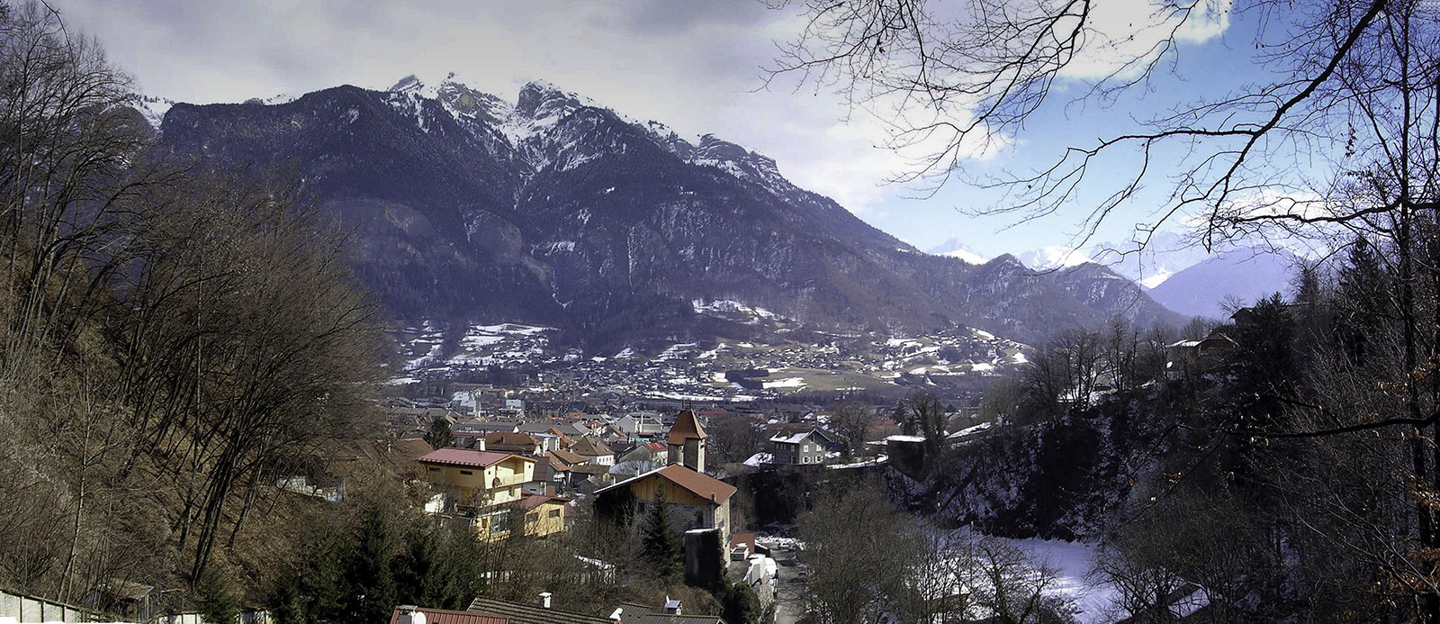
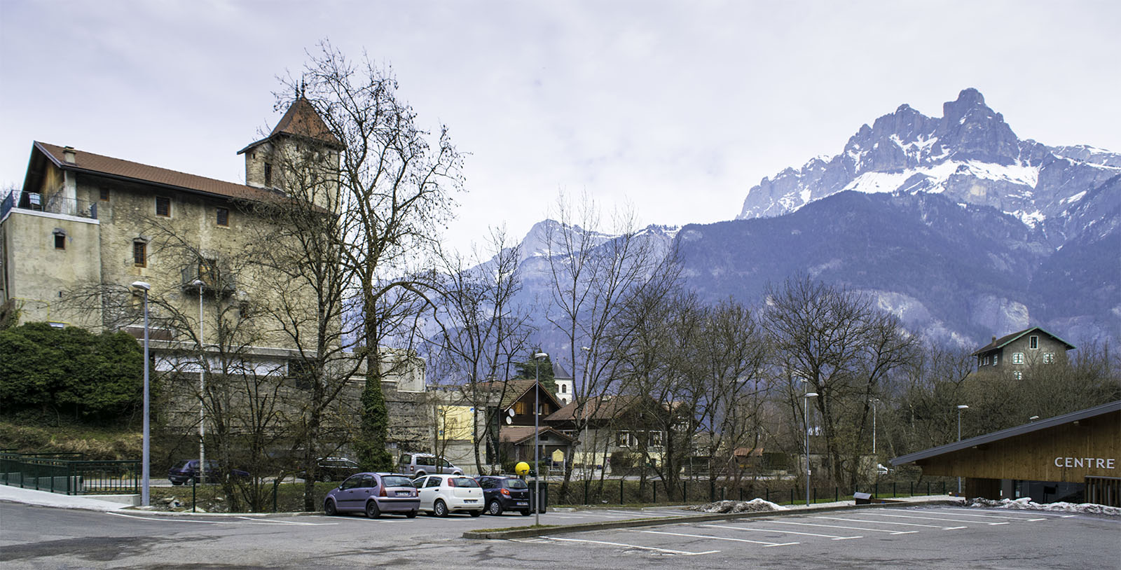
From the corner of the Route de Doran Turner continued his exploration along the lip of the Fors de Sallanches. Today there is a road, the Route de Levaud, which after a couple of hundred yards passes the Chapel of the Immaculate Conception. The chapel post-dates Turner’s visit – it was built in 1855 – but Turner made his second large sketch here, and presumably the chapel site was selected since it offered such a fine prospect. It is a popular site today, providing a decent uphill walk from the town, and a splendid sun-bathed spot for reflection or a picnic. When I was there in March the ground was sprinkled with primroses enjoying the early-season warmth. The view relates remarkably well to the sketch. The Tour de Disonche is obscured behind a tree to the left, but the church tower points directly to the summit of the Aiguille de Varan, and the tower of the Chateau des Rubins at the right points directly to Mont Blanc. Above and to the left of the Chateau des Rubins is the Chateau Breche noted in the previous sketch, and in the centre of the composition we can trace the course of the Torrent de Sallanches, spanned in Turner’s sketch by at least two bridges. It seems to give the complete picture of Sallanches. Most artists would have stopped there.
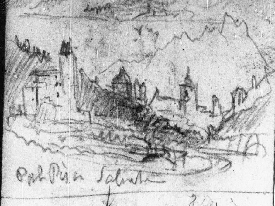
He also made his way down into the valley of the Sallanches river to the Chateau des Rubins. There is an old path that zig-zags down through the trees from the Chapel and perhaps this was Turner’s own route. He took two quick sketches in his pocket sketchbook looking past the Chateau des Rubins to the church, town and Aiguille de Varan. John Ruskin later sketched the Chateau des Rubins with the Aiguille de Varan behind, and his approach contrasts so markedly with Turner that I append his study at the end of this article as a postscript. For now, Turner does not seem to have thought that either subject warranted treatment on the larger sheets, but the systematic way in which he quartered the compass around his principal landmarks is typical of his practice. It gave him the co-ordinates to comprehend the geography of his site. In passing it is worth noting that Turner called the Chateau des Rubins the ‘Tour Pisa’ or the ‘Pal[ace] Pisa’. Presumably he was told that – he probably often hired the services of a local guide – but I have found no confirmation of that name in any of the easily available literature. In a third turn of the compass he made a final sketch in his pocket book of The towers of Sallanches with the Aiguille de Varan behind. We can work out the that the viewpoint is a little further downstream of the last, since the towers of Disonche, de la Frasse and the church are opened a little further, but I did not manage to confirm the identity of the building in the foreground, nor of that apparently to the left of the Tour de Disonche. I would be grateful to hear from anyone that might be able to amplify the detail and would be happy to publish any comments that help to develop the account.
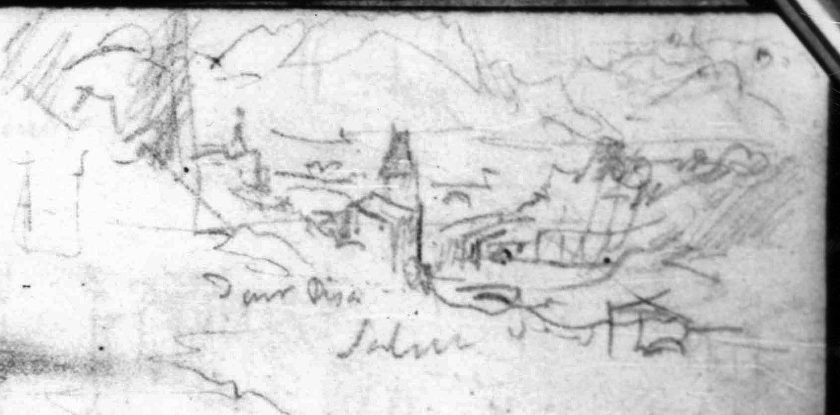
Two Sketches; The Head of Lake Geneva from near Lausanne; From above Sallanches in the Arve Valley to the Aiguille de Varan and Mont Blanc (detail of sketch of Sallanches), 1836
Pencil on paper, page width 113 mm
From the Val d’Aosta sketchbook, Tate Britain, London, TB CCXCIII 62 detail
From above the Chateau des Rubins, looking from the entrance to the Gorges de Levaud to Sallanches and the Aiguille de Varan.
Image courtesy of Tate; to see the original image in the online catalogue of the Turner Bequest click on the following link, then press your browser’s ‘back’ button to return to this page:
http://www.tate.org.uk/art/research-publications/jmw-turner/joseph-mallord-william-turner-two-sketches-the-head-of-lake-geneva-from-near-lausanne-from-r1168042
Photograph by David Hill, taken 9 March 2005, 10.36 am.
Looking over the Chateau des Rubins to Sallanches with the Aiguille de Varan in the background. up. Taken from the path leading down from the Chapel of the Immaculate Conception. The church tower is hidden behind the trees at the left. Ten years ago exactly, I note with some surprise, and much more snow than this year.
Click on image to enlarge.
Four Sketches: Arras; Storm in the ?Arve Valley; From above Sallanches; and From Pré St Didier in the Val d’Aosta (detail of sketch of Sallanches), 1836
Pencil on paper, page width 113 mm
From the Val d’Aosta sketchbook, Tate Britain, London, TB CCXCIII 70a detail
From opposite the Chateau des Rubins, scanning across the Tour de Disonche with a glimpse of the Tour de la Frasse beyond to the right, to the Church of St Jacques and the Aiguille de Varan. Turner routinely quartered the compass at his major sites, so as to be able to mentally rotate the main co-ordinates of his geography. The viewpoint is now occupied by the new Centre Levaud Sports Hall, though Turner compresses his elements together somewhat. My photograph is somewhat to the left of the centre.
Image courtesy of Tate; to see the original image in the online catalogue of the Turner Bequest click on the following link, then press your browser’s ‘back’ button to return to this page:
http://www.tate.org.uk/art/research-publications/jmw-turner/joseph-mallord-william-turner-four-sketches-arras-storm-in-the-arve-valley-from-above-r1144717
Photograph by David Hill taken 10 March 2015, 12.51 GMT
Click on image to enlarge.

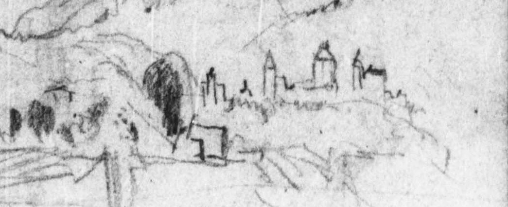
Two Sketches: The Tomb of Thomas Balsall in the Sanctuary of Holy Trinity Church, Stratford-Upon-Avon; A Town in an Alpine Valley (detail of the latter, now identified as Sallanches), 1836
Pencil on paper, page width 113 mm
From the Val d’Aosta sketchbook, Tate Britain, London, TB CCXCIII 81 detail
In my recent listing of these sketches for the online catalogue of the Turner Bequest at the Tate (see below) I tentatively suggested that this might show Sallanches. This can now be confirmed. The towers of de Disonche, de la Frasse and the church are seen before the Aiguille de Varan. From their angle we can work out that Turner’s viewpoint is a little below that of f.70a, above, but I could not confirm the identity of the foreground tower, nor that to the left of the Tour de Disonche.
Image courtesy of Tate; to see the original image in the online catalogue of the Turner Bequest click on the following link, then press your browser’s ‘back’ button to return to this page:
http://www.tate.org.uk/art/research-publications/jmw-turner/joseph-mallord-william-turner-two-sketches-the-tomb-of-thomas-balsall-in-the-sanctuary-of-r1144738
Turner made one final large sketch at Sallanches from a viewpoint on the Route de Levaud beyond the Chapel of the Immaculate Conception, but its proved impossible to stand on the actual ground or take a photograph. We can, however, work out from the angles of view in the sketch on the Tour de Disonche, Church, Chateau des Rubins, Aiguille de Varan and the bridges over the Sallanches river, that the viewpoint is hereabouts, a little further away from the town than the chapel of the immaculate conception, so as to bring the Chateau des Rubins into play in the centre foreground. Walking back and forth on my recent visit, it became frustratingly clear that that all the land in this area, between the Route de Lavaud and the valley, has been appropriated for private housing and Turner’s view lost to public perusal. So if you happen to be the proprietor of the following view, I would be delighted to hear from you. All the more so if you might be prepared to admit me to take a photograph!
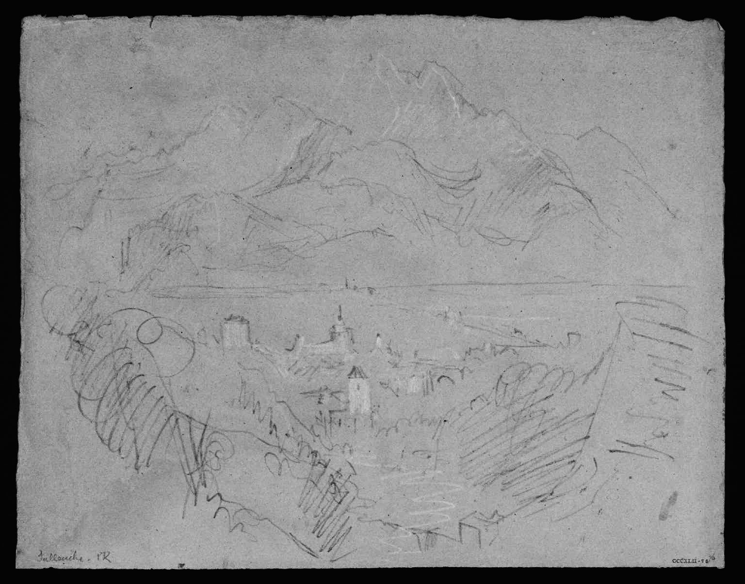
The Arve Valley, with the Aiguille de Varan from above Sallanches, 1836
Pencil and scratching-out on grey paper, faded to a pinkish tone, 238 x 312 mm
‘Miscellanous: Black and White’, Tate Britain, London, TB CCCXLII 76
From the left scarp of the torrent de Sallanches, a little way further up the Route de Lavaud from the Chapel of the Immaculate Conception, so as to bring the Chateau des Rubins and the Church of St Jacques more in line, and excluding Mont Blanc to the right. The area today is enclosed by private houses.
Image courtesy of Tate; to see the original image in the online catalogue of the Turner Bequest click on the following link, then press your browser’s ‘back’ button to return to this page:
http://www.tate.org.uk/art/artworks/turner-sallenche-d34278
The last pencil sketch is very close to the watercolour. The relationship of the placement and form of the church, the specific indications of the distant mountains, the slopes falling from the left foreground and the suggestion of the road in the middle distance running diagonally to St Martin, are sufficient in my eyes to make certain the identification of Sallanches.
Click on any image to open gallery and captions:


Turner’s 1836 sketches at Chambery offer no such comparison. Warrell’s argument is more derived from a stylistic affinity with a watercolour sketch from the end of the tour which unmistakably does show Chambery.
Click on image to open gallery and captions:


The stylistic relation is, indeed close, and Warrell’s argument charts a line of development of Turner’s watercolour sketching style during the tour that culminates in these two subjects. In a nutshell: Chambery is Turner’s last major subject of the tour, so his Chambery sketch is the tour’s culminating point. The Sallanches is in the same style, so it must also be of Chambery. The topography of Sallanches is, however, I firmly believe, completely solid. Some other explanation for the stylistic relation must be sought.
At this point it might be worth amplifying the context. One of my principal interests in the tour of 1836 is that it is certain that Turner sketched in watercolour direct from nature. Several modern scholars have tended to question this practice in relation to other tours (principally in Germany and France) and it has become something of a crusade for me to put him on the spot with colours in hand wherever I can. 1836 is especially important to me for in this case we can be certain about his practice. He had a travelling companion, H.A.J.Munro of Novar, and from him we have direct testimony of Turner colouring from nature. Munro remembered, for example; ‘colours coming out’ once they reached Switzerland. Their first port of call in Switzerland was Geneva, and thereafter Turner seems to have sketched in colours regularly. Munro’s testimony also informed the account given by Walter Thornbury in his first full-length biography of Turner. Form that we discover that sketching in colours could be a frustrating business, and it is worth quoting Thornbury’s account at length:
Mr Munro found that Turner enjoyed himself in his way – a sort of honest Diogenes way. He disliked teasing questions as to how he got this or that colour. On one occasion in the Aosta valley, Turner was very dissatisfied with a sketch. He altered and sponged until the drawing had got a white greenness about it which was not pleasant. He got quite fretful about this, and began to abuse colour-sketching, saying, “I could have done twice as much with the pencil.”
His first enquiry in the morning, when they started to sketch, was always, “have you got the sponge?” because it was with the sponge he obtained many of his misty and aerial effects.
He never rhapsodised about scenery, but set hard at work at some distance from Mr Munro, silent, concentrated (and generally a good deal higher). So as to obtain more distance and more of a bird’s-eye view. He took quick sketches, and then finished them afterwards quietly (by the help of his tremendous memory) at the inn. He had a horror of what Wilson called “being too mappy.” If you bore with his way, it was easy to get on very pleasantly with him: indeed there was a sort of half-resolution come to that Turner and Mr Munro should visit the East together.
Turner used no maul-stick, his touch was sure and decisive; his materials were of the rudest: brushes worn away to single hairs, and now trebly as valuable as when new. Turner’s way of showing a kindness was peculiar; he seemed to put on a certain roughness, to conceal his real feelings. One day (I believe it was near Sallanche) he found Mr Munro (who, bye-the-bye, is an artist himself of most refined taste) in some difficulty with a sketch. He did not appear to notice it, but growlingly took up a new drawing-pad that was lying near (the paper he used was of a rough kind, and generally wrinkled in the most uncomfortable way by repeated washes), and off he went to “see what he could do with it.” He returned in about two hours with the paper squared into four sketches, each in a different state of completion. This was evidently his rough, kind, way of showing an amateur friend the way of pushing forward a sketch. These sketches I have seen, and to me they seem invaluable. There are first rough pencilling loops for trees, and lines marking the horizon and chief masses. Then come brown dabs of marking-out colour, then washes for sky and water, till in the last sketch sapphire hills and touches of heaven seem breaking through the chaos, and every inch of colour is radiant with knowledge and beauty.
The account tells us that Turner frequently started sketches on the spot and worked on them afterwards at the inn. It is possible that the watercolours of Sallanches and Chambery were worked on together, even side by side, but that would not deny their separate plein-air origins. The account further tells us that Turner persevered with colour despite his sometimes becoming frustrated with it. This might prompt us to consider what he could achieve with colour that could not be done with the pencil. The answer is effect. Pencil can record form and detail, but the circumstantial phenomena of light, colour and atmosphere require colour. And every one of Turner’s 1836 watercolour sketches is based in its own particular phenomenal occasion. In this case the Aiguille de Varan is north-east of Sallanches, so the sun rises behind it in midsummer. We do not know the specific dates when Turner was at Sallanches in 1836, but he generally made his continental tours between July and September. He would have been about three weeks into his tour, so we can surmise the end of July or early August. At that time the sun rises over the right shoulder of the Aiguille.

That chimes with the effect here, with the church backlit and the right part of the mountain bleached out by the light. Having explored the area thoroughly in his pencil sketches, he knew exactly where the best compositions were to be had, and rising early as was his routine habit, was ready to observe the morning clouds over the peak filling with light and dissolving. This rather argues against the drawings being made together. It seems more likely that at the age of sixty-one, the greatest ever painter in watercolour had a wide repertoire of styles and approaches at his disposal, and applied them as his subject or creative agenda warranted.
And yet the effect is not merely naturalistic. Munro told Thornbury that Turner wanted to avoid ‘being too mappy’. He was an artist, after all, and he wanted to represent more than matter-of-fact topography and effect. So although he took care to understand the facts (and this harder than most would assume) his proper work was to see past that to the sublime; that which resides beyond ordinary apprehension.
I am reminded of a distant but still clear experience in everyday apprehension. Back in the late 1980s when teaching Fine Art at Bretton Hall College, we used to take the students every Spring to Anglesey. It was a pleasure to work alongside the painter David Walker Barker, who, apart from having all the technical bravura of Turner, also has a similar sense of the sublime and an impressive knowledge of geology. He told me about the rocks of Ynys Llanddwyn at the south west tip of the island. Right at the end of the peninsula, where there is a little harbour and old light-tower overlooking the hills of Snowdonia across the Menai Straits, the rocks are like God’s plasticine. Slabs of green with red eyelets, blue-grey veined through with carmine, purples and green flecked with ruby. This seemed a splendid place to take the students drawing and so with big billing I led them on the two-mile trek across Newborough Sands and onto the end of the peninsula. ‘Here we are,’ I eventually announced – ‘look around and see what you can find.’ Ten minutes later a circle of unimpressed faces informed me that the rocks were in fact all grey. And so they were, as lumpen and dull as rocks might ordinarily be. It was a decent breezy day so it was worth setting them to draw in any case. After half an hour we started to see it: A tint in a pebble; a hue in a vein spreading across an outcrop. After an hour we did not have colour enough and by the end of the day we had used every stick and tube and our sketchbooks were like an India spice stall.
So what happened? The rocks did not change, but what we saw initially as grey and dull we later really saw as a riot of colour. Technically our minds attuned themselves to the subject, and our perception recalibrated itself. Such is the product of considered attention, and it becomes habitual in those that practice it regularly. So produce that, if you will, to the practice of Turner, which by 1836 had been sensitised daily over a period of fifty years. We can see the effect in his watercolour sketch of Sallanches. As Thornbury said of one of the drawings in this series, and he might well have been talking about this very drawing: ‘sapphire hills and touches of heaven seen breaking through the chaos, and every inch of colour is radiant with knowledge and beauty.’

Other drawings by Turner in the Sallanches area [and elsewhere]
To complete the references for the reader this gallery reproduces a few sketches of St Martin not discussed in detail in the main text. It also reproduces one sketch currently catalogued by the Tate as Sallanches, but which actually shows a different site altogether.
It worth remarking of the pencil sketches particularly, that they are rather more conventional in their approach to the topography than those discussed in the main text. That at the Huntington Library seems comparatively clichéd, and that at the Fitzwilliam, positively populist. The drawings in the main text seem much more driven and striving. The explanation may be as simple as those in the main text belong to Turner’s private campaign, but the two pencils here were made for a public, in the person of Turner’s travelling companion H.A.J.Munro of Novar. As we have already read, Turner inevitably found himself drawn into teaching and demonstration. The pencils were probably made for his benefit, and it is not impossible that Munro was their original owner.
Click on any image to open the image and captions in a gallery format.


Ruskin and the Chateau de Rubins, Sallanches, 1860


Called ‘A Building and a Tower in the Alps’ when exhibited at Agnew’s in 2003, and identified by myself as the Chateau des Rubins at Sallanches on a site visit of 9 March 2005. The identification was published by Sotheby’s when the watercolour was sold in 2008.
The high colour and the vignetted area of attention is very distinctive. When the watercolour was exhibited at Agnew’s in 2003 the catalogue likened this drawing to studies that Ruskin made in Fribourg c.1856, The closest comparison in spirit, style and tight concentration of scope is a study of the Glacier de Bois, Chamonix, at the Whitworth Art Gallery, Manchester, which is dated 1860.
Sallanches and St Martin were key sites for John Ruskin. He was particularly fond of the old Hotel du Mont Blanc at St Martin and on a late visit in 1882 even considered buying it. He generally stopped at the old inn or at the Bellevue in Sallanches, and particularly enjoyed walking on the hills above the town. He visited to town something like a dozen times from his first in 1833 to the last in 1888. As his diaries record, on 10 June 1849 whilst walking up the hill towards St Gervais he had a formative revelation. He found himself crushed by too wide a panorama. He did not have the mental scope of Turner and thenceforth resolved to proceed by small steps and a narrow compass. This watercolour is a perfect instance of how powerful his refocused vision could be. The subject reflects Ruskin’s interest in the language of architecture, here exploring how the architectural elements appear to take their nature from the masses of rock above. Ruskin draws that sharply into consideration by making the eye switch suddenly from foreground to distance to find the subsidiary, but infinitely grander mass of the mountain behind, with its own lesser and supporting elements holding up the main act, a little like a fairground human pyramid. If the opportunity arose it would be interesting to make a thorough survey of all of Ruskin’s subjects in the area.
Ruskin’s exact view point is on the left bank of the Torrent de Sallanches, a short way above the Chateau des Rubins. It was possible to identify and stand upon the exact spot when I visited in March 2015, but the view was somewhat obscured by twigs and branches.
AND FINALLY…
SALLANCHES, March 2015. Click on any image to open in gallery.


reading your study on Sallanches, i tried to see your
http://www.tate.org.uk/art/research-publications/jmw-turner/val-daosta-sketchbook-r1167921#entry-main
announced in your introduction but the webpage does not works:
” the page you asked for is note here: error 404″ answered the tate website.
Is there any other url to use for going to your first study?
Très cordialement
Roland Courtot
I am grateful to Roland Courtot for bringing this broken link to my attention. This is now fixed and directs to the Tate website and my introduction to my entries for Turner’s 1836 sketchbooks. DH
http://www.tate.org.uk/art/research-publications/jmw-turner/sketchbooks-used-on-tour-to-the-alps-r1144578#synopsis